Geographical Surveys West of the 100th Meridian (U.S.)
Published / Created:
1879
Call Number:
841 1879A
Container / Volume:
BRBL_00596
Image Count:
1
Resource Type:
Maps, Atlases & Globes
Alternative Title:
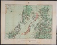
Land classification map of part of southern New Mexico, atlas sheet no. 84 (B)
Description:
"7"--Verso., "Expeditions of 1877.", "Issued June 30, 1879.", "Weyss, Lang and Herman, del."--Lower right border., Includes atla, Relief shown by hachures and spot heights., and Shows land types: agricultural (with irrigation), timber, grazing, and arid and barren.
Geographical Surveys West of the 100th Meridian (U.S.)
Published / Created:
[1878]
Call Number:
841 1878B
Container / Volume:
BRBL_00596
Image Count:
1
Resource Type:
Maps, Atlases & Globes
Alternative Title:
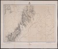
Part of southern New Mexico, atlas sheet no. 84 (B)
Description:
"10"--Verso., "Weyss, Lang and Herman, del."-, Differs from 1879 map of identical title in that eastern relief missing on this map and type/text size smaller around margins., and Relief shown by hachures and spot heights. Relief not shown on eastern half of map.
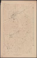
"Datum is mean sea level, based upon elevation of Oregon Short Line R.R. Station at Eureka taken as 6387 feet.", "Description of Topographic map of the United States" on verso., and "R.U. Goode, Geographer in charge. Triangulation by S.S. Gannett. Topography by W.T. Griswold and R.B. Marshall."
Publisher:
U.S. Geological Survey,
Subject (Geographic):
Juab County (Utah)--Maps and Utah County (Utah)--Maps
Subject (Name):
Gannett, Samuel S. (Samuel Stinson), 1861-1939, Goode, Richard Urquhart, 1858-1903, Griswold, W. T. (William Tudor), 1859-1931, and Marshall, R. B. (Robert Bradford), 1867-1949