Search
You Searched For
Search Results
- Creator:
- United States. Office of Strategic Services
- Published / Created:
- 1943
- Call Number:
- 36gma 1943
- Container / Volume:
- BRBL_00130
- Image Count:
- 1
- Resource Type:
- Maps, Atlases & Globes
- Found in:
- Beinecke Rare Book and Manuscript Library > "Greater Germany" inland waterways.
- Creator:
- United States. Office of Strategic Services
- Published / Created:
- 1945
- Call Number:
- 36cb 1945
- Container / Volume:
- BRBL_00127
- Image Count:
- 1
- Resource Type:
- Maps, Atlases & Globes
- Found in:
- Beinecke Rare Book and Manuscript Library > "Greater" Germany caves and cave regions.
- Creator:
- United States. Office of Strategic Services. Research and Analysis Branch
- Published / Created:
- 1945
- Call Number:
- 36eb 1945B
- Container / Volume:
- BRBL_00127
- Image Count:
- 1
- Resource Type:
- Maps, Atlases & Globes
- Found in:
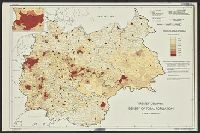
- Beinecke Rare Book and Manuscript Library > "Greater" Germany, density of total population by Kreise or similar units excluding cities 10,000 and over.
- Creator:
- United States. Office of Strategic Services. Research and Analysis Branch
- Published / Created:
- 1945
- Call Number:
- 36eb 1945C
- Container / Volume:
- BRBL_00127
- Image Count:
- 1
- Resource Type:
- Maps, Atlases & Globes
- Found in:
- Beinecke Rare Book and Manuscript Library > "Greater" Germany, density of total population by Kreise or similar units.
- Creator:
- United States. Office of Strategic Services. Research and Analysis Branch
- Published / Created:
- 1945
- Call Number:
- 36eb 1939A
- Container / Volume:
- BRBL_00127
- Image Count:
- 1
- Resource Type:
- Maps, Atlases & Globes
- Found in:
- Beinecke Rare Book and Manuscript Library > "Greater" Germany, population dependent upon commercial and service occupations (by Kreise 1939).
- Creator:
- United States. Office of Strategic Services. Research and Analysis Branch
- Published / Created:
- 1945
- Call Number:
- 36eb 1945A
- Container / Volume:
- BRBL_00127
- Image Count:
- 1
- Resource Type:
- Maps, Atlases & Globes
- Found in:
- Beinecke Rare Book and Manuscript Library > "Greater" Germany. : population change by Kreise, circa 1933-1939.
- Creator:
- United States. Office of Strategic Services. Research and Analysis Branch
- Published / Created:
- 1945
- Call Number:
- 36eb 1939
- Container / Volume:
- BRBL_00127
- Image Count:
- 1
- Resource Type:
- Maps, Atlases & Globes
- Found in:
- Beinecke Rare Book and Manuscript Library > "Greater" Germany; population dependent upon agriculture (by kreise, 1939)
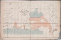
- Creator:
- Maury, Matthew Fontaine, 1806-1873
- Published / Created:
- 1853
- Call Number:
- 11DB 1851A-2
- Container / Volume:
- BRBL_00774
- Image Count:
- 1
- Resource Type:
- Maps, Atlases & Globes
- Found in:
- Beinecke Rare Book and Manuscript Library > A chart showing the favorite resort of the sperm and right whale [cartographic material] / by M.F. Maury L.L.D. Lieut. U.S. Navy ; constructed from Maury's whale chart of the world by Robt. H. Wyman Lieut. U.S.N.
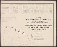
- Creator:
- Graham, J. D. (James Duncan), 1799-1865
- Published / Created:
- 1836
- Call Number:
- 764 C172 1836
- Container / Volume:
- BRBL_00456A
- Image Count:
- 4
- Resource Type:
- Maps, Atlases & Globes
- Found in:
- Beinecke Rare Book and Manuscript Library > A map of the extremity of Cape Cod : including the townships of Provincetown & Truro, with a chart of their sea coast and of Cape Cod Harbour, State of Massachusetts / executed under the direction of Major J.D. Graham ... 1833, '34, & '35.
- Creator:
- United States. Dept. of the Treasury. Bureau of Statistics
- Published / Created:
- [1899]
- Call Number:
- 60fab 1899A
- Container / Volume:
- BRBL_00329
- Image Count:
- 1
- Resource Type:
- Maps, Atlases & Globes
- Found in:
- Beinecke Rare Book and Manuscript Library > Africa, its political divisions and commercial routes / Norris Peters Co., photo-litho., Washington, D.C.
- Creator:
- United States. Dept. of the Treasury. Bureau of Statistics
- Published / Created:
- 1899
- Call Number:
- 60fab 1899
- Container / Volume:
- BRBL_00329
- Image Count:
- 1
- Resource Type:
- Maps, Atlases & Globes
- Found in:
- Beinecke Rare Book and Manuscript Library > Africa, its political divisions and commercial routes / Norris Peters Co., photo-litho., Washington, D.C.
- Creator:
- Helm, Charles J
- Published / Created:
- 1906
- Call Number:
- 848 1906
- Container / Volume:
- BRBL_00630
- Image Count:
- 1
- Resource Type:
- Maps, Atlases & Globes
- Found in:
- Beinecke Rare Book and Manuscript Library > Alaska / compiled from the official records of the General Land Office, U.S. Coast and Geodetic Survey, Geological Survey, Canadian and other sources, under the direction of Frank Bond ; compiled by M. Hendges ; revised and drawn by Charles J. Helm.
- Creator:
- United States Coast Survey
- Published / Created:
- 1869
- Call Number:
- 848 1869
- Container / Volume:
- BRBL_00630
- Image Count:
- 1
- Resource Type:
- Maps, Atlases & Globes
- Found in:
- Beinecke Rare Book and Manuscript Library > Alaska and adjoining territory / drawn by H. Lindenkohl.
- Creator:
- Geological Survey (U.S.)
- Published / Created:
- 1898
- Call Number:
- 848 C793 1898
- Container / Volume:
- BRBL_00632
- Image Count:
- 1
- Resource Type:
- Maps, Atlases & Globes
- Found in:
- Beinecke Rare Book and Manuscript Library > Alaska military expedition : in charge of Captain W.R. Abercrombie, U.S.A. Copper River and adjacent territory / topography by P.G. Lowe, F.C. Schrader, and Emil Mahlo.
- Creator:
- Geological Survey (U.S.)
- Published / Created:
- 1909
- Call Number:
- 848 C26 1909
- Container / Volume:
- BRBL_00632
- Image Count:
- 1
- Resource Type:
- Maps, Atlases & Globes
- Found in:
- Beinecke Rare Book and Manuscript Library > Alaska, Casadepaga quadrangle / U.S. Geological Survey.
- Creator:
- Geological Survey (U.S.)
- Published / Created:
- [1908]
- Call Number:
- 848 F15 1908
- Container / Volume:
- BRBL_00632
- Image Count:
- 1
- Resource Type:
- Maps, Atlases & Globes
- Found in:
- Beinecke Rare Book and Manuscript Library > Alaska, Fairbanks special map / U.S. Geological Survey.
- Creator:
- Geological Survey (U.S.)
- Published / Created:
- 1906
- Call Number:
- 771cbf Al13 1906
- Image Count:
- 1
- Resource Type:
- Maps, Atlases & Globes
- Found in:
- Beinecke Rare Book and Manuscript Library > Albany and vicinity, New York.
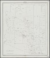
- Creator:
- United States. Bureau of the Census
- Published / Created:
- 1934
- Call Number:
- 842fb 1930
- Container / Volume:
- BRBL_00600
- Image Count:
- 1
- Resource Type:
- Maps, Atlases & Globes
- Found in:
- Beinecke Rare Book and Manuscript Library > Arizona : minor civil divisions / Department of Commerce, Bureau of the Census, 1930.
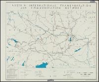
- Creator:
- United States. Office of Strategic Services. Research and Analysis Branch
- Published / Created:
- 1945
- Call Number:
- 42gm 1945
- Container / Volume:
- BRBL_00245
- Image Count:
- 1
- Resource Type:
- Maps, Atlases & Globes
- Found in:
- Beinecke Rare Book and Manuscript Library > Austria: international transportation and communication network [cartographic material] / R & A, OSS.