Search
You Searched For
Search Results
- Published / Created:
- [1898]
- Call Number:
- 855hc 1898R
- Container / Volume:
- BRBL_00765
- Image Count:
- 1
- Resource Type:
- Maps, Atlases & Globes
- Found in:
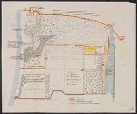
- Beinecke Rare Book and Manuscript Library > Sketch of a reconnaisance made by Major T.H. Belt, U.S. Vol. Engr. : accompanied by Major L.H Strother, U.S. Vol. Engr. Lieut. R.W. Means, 1st Colo. Inf. Aug. 10, 1898.
- Creator:
- U.S. Coast and Geodetic Survey
- Published / Created:
- 1898
- Call Number:
- 855hc 1898Q
- Container / Volume:
- BRBL_00765
- Image Count:
- 1
- Resource Type:
- Maps, Atlases & Globes
- Found in:
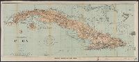
- Beinecke Rare Book and Manuscript Library > Cuba : part of chart "E" / Treasury Department, U.S. Coast and Geodetic Survey, Henry S. Pritchett, Superintendent.
- Published / Created:
- [1898]
- Call Number:
- 855hc 1898H
- Container / Volume:
- BRBL_00765
- Image Count:
- 1
- Resource Type:
- Maps, Atlases & Globes
- Found in:
- Beinecke Rare Book and Manuscript Library > [Map showing fortifications around the mouth of the San Juan River, Cuba during the War of 1898.]