Contour interval 100 feet. Datum is mean sea level., Includes examples of "Conventional signs" used on the map in the upper right margin., and Relief shown by contours and spot heights.
Publisher:
Engraved and printed by the U.S. Geological Survey,
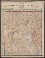
Contour interval 100 feet. Datum is mean sea level., Dissected and mounted on linen., Includes examples of "Conventional signs" used on the map in the upper right margin., and Relief shown by contours and spot heights.
Publisher:
Engraved and printed by the U.S. Geological Survey,
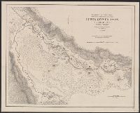
"1871.", "Approximate latitude of Park Pt., 44⁰23ʹ, approximate longitude of Park Pt., 110⁰20ʹ.", "Soundings are in fathoms.", At head of title: Department of the Interior, U.S. Geological Survey of the Territories., From the Survey's 5th annual report., and Relief shown by hachures and spot heights. Depths shown by soundings.
Publisher:
Geological Survey of the Territories,
Subject (Geographic):
Yellowstone Lake (Wyo.)--Maps and Yellowstone National Park--Maps
Subject (Name):
Elliott, Henry Wood, 1846-1930, Geological Survey of the Territories (U.S.), Hayden, F. V. (Ferdinand Vandeveer), 1829-1887, and Schönborn, A