Search
You Searched For
Search Results
- Creator:
- United States. Office of Strategic Services. Research and Analysis Branch
- Published / Created:
- 1943?]
- Call Number:
- 381hc 1943
- Container / Volume:
- BRBL_00174
- Image Count:
- 1
- Resource Type:
- Maps, Atlases & Globes
- Found in:
- Beinecke Rare Book and Manuscript Library > Brittany, south coast [cartographic material] : beaches and objectives / compiled and drawn in the Branch of Research and Analysis, OSS.
- Published / Created:
- 1851].
- Call Number:
- 11cfk 1850B-3
- Container / Volume:
- BRBL_00770
- Image Count:
- 1
- Resource Type:
- Maps, Atlases & Globes
- Found in:
- Beinecke Rare Book and Manuscript Library > Chart Of The North East Trade Winds [cartographic material] / National Observatory.
- Creator:
- Kane, Elisha Kent
- Published / Created:
- 1855]
- Call Number:
- 74 1855
- Container / Volume:
- BRBL_00394
- Image Count:
- 1
- Resource Type:
- Maps, Atlases & Globes
- Found in:
- Beinecke Rare Book and Manuscript Library > Chart exhibiting the discoveries of the Second-American-Grinnell-Expedition in search of Sir John Franklin : unrevised from the original material and projected on the spot / E. K. Kent.
- Creator:
- United States. Dept. of the Treasury. Bureau of Statistics
- Published / Created:
- 1900?]
- Call Number:
- 23gmf 1900
- Container / Volume:
- BRBL_00021
- Image Count:
- 1
- Resource Type:
- Maps, Atlases & Globes
- Found in:
- Beinecke Rare Book and Manuscript Library > Commercial highways between United States and Asia and the islands of the Pacific / U.S. Treasury Department, Bureau of Statistics.
- Creator:
- Garstin, D. V
- Published / Created:
- 1965
- Call Number:
- 844gmb R524 1965
- Container / Volume:
- BRBL_00617
- Image Count:
- 1
- Resource Type:
- Maps, Atlases & Globes
- Found in:
- Beinecke Rare Book and Manuscript Library > Desert Riders trail map / by D.V. Garstin & N.K. Blanchard.
- Creator:
- Geological and Geographical Survey of the Territories (U.S.)
- Published / Created:
- [1879]
- Call Number:
- 833g 1879
- Container / Volume:
- BRBL_00586
- Image Count:
- 1
- Resource Type:
- Maps, Atlases & Globes
- Found in:
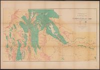
- Beinecke Rare Book and Manuscript Library > Economic map of portions of Wyoming, Idaho and Utah / Department of the Interior, U.S. Geological and Geographical Survey of the Territories ; F.V. Hayden, U.S. geologist in charge.
- Creator:
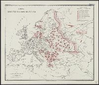
- United States. Office of Strategic Services. Research and Analysis Branch
- Published / Created:
- 1943?]
- Call Number:
- 30gme 1943
- Container / Volume:
- BRBL_00038
- Image Count:
- 1
- Resource Type:
- Maps, Atlases & Globes
- Found in:
- Beinecke Rare Book and Manuscript Library > Europe : selected railroad objectives / compiled and drawn in the Branch of Research and Analysis, OSS.
- Creator:
- United States. Army. Corps of Engineers
- Published / Created:
- 1872?]
- Call Number:
- 7821 1872
- Container / Volume:
- BRBL_00506
- Image Count:
- 1
- Resource Type:
- Maps, Atlases & Globes
- Found in:
- Beinecke Rare Book and Manuscript Library > Explorations and surveys south of Central Pacific R.R., War Department : preliminary topographical map embracing in skeleton a portion only of the notes from surveys made in accordance with Par.II Special Orders No. 109 War Dept., March 18th, 1871 and let
- Published / Created:
- 1898
- Call Number:
- 848 T15 1898
- Container / Volume:
- BRBL_00634
- Image Count:
- 1
- Resource Type:
- Maps, Atlases & Globes
- Found in:
- Beinecke Rare Book and Manuscript Library > Explorations in Alaska 1898 portions of Tanana and White Rivers.
- Creator:
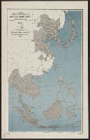
- United States. Board of Economic Warfare. Enemy Branch
- Published / Created:
- 1943
- Call Number:
- 556gme 1943
- Container / Volume:
- BRBL_00294
- Image Count:
- 1
- Resource Type:
- Maps, Atlases & Globes
- Found in:
- Beinecke Rare Book and Manuscript Library > Far East, Japanese occupied area, major railroads [cartographic material] / Board of Economic Warfare, Enemy Branch ; drawn in R. and A., OSS.