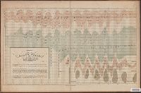
Chart including Smith Strait, Peabody Bay, and Kennedy Channel along Grinnellland [i.e. Grinnell Peninsula], Arctic Canada.
Description:
"Ackerman Lith.", Senate Ex. Doc., 1st session, 34th Congress ; no.1., and With detailed tracks and location of caches, as well as Esquimaux village sites.
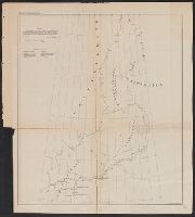
In upper right margin: No XII., Mostly shows valley of Truandó River., and Profile along the surveyed route; Profile along the proposed ship canal route.
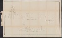
"No. IV." in upper right margin., "To accompany report by Rear Admiral C.H. Davis, U.S.N., ordered by resolution of the Senate of the United States of March 19, 1866.", and Includes profile of the Harbour of San Juan de Nicaragua.
United States. Army. Corps of Topographical Engineers
Published / Created:
1850 [i.e. 1851]
Call Number:
80 1850D
Container / Volume:
BRBL_00534
Image Count:
2
Resource Type:
Maps, Atlases & Globes
Description:
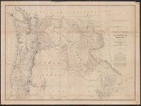
Date on map is 1850, however Wheat writes " ... ostensibly published in 1850, though it could not have gone to the engravers, Sherman and Smith of New York, until early in 1851" (Mapping the transmississippi West, 696)., On 2 sheets (each 62 x 105 cm.) and mounted on linen., and Relief shown by hachures.
United States. Army. Corps of Topographical Engineers
Published / Created:
1859
Call Number:
846 1859
Container / Volume:
BRBL_00620
Image Count:
1
Resource Type:
Maps, Atlases & Globes
Description:
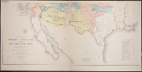
At head of title: Department of Oregon., Includes list of authorities and note., Relief shown by shading., and Shows Oregon, Washington, Idaho and Western Montana.
Publisher:
The Bureau],
Subject (Geographic):
Northwest, Pacific--Maps, Oregon--Maps, and Washington (State)--Maps
Subject (Name):
Dougal, William H., 1822-1895, Floyd, John B. (John Buchanan), 1806-1863, and United States. Army. Dept. of Oregon
Includes "Note" and "Authorities.", Incorporates note and surveys added after Jan. 8, 1858., Relief shown by hachures and spot heights., and Shows Indian tribal locations, military posts, routes and dates of expeditions and surveys.
Publisher:
War Dept.,
Subject (Geographic):
West (U.S.)--Maps
Subject (Name):
Siebert, Selmar and United States. War Dept
Subject (Topic):
Pacific railroads--Explorations and surveys--Maps and Railroads--West (U.S.)--Maps
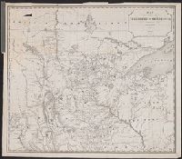
"35th Congress, 1st Session. Printed by order of the U.S. Senate." and Preliminary report of explorations in Nebraska and Dakota in the years 1855-'56-'57," originally printed in the appendixes to the Report of the Secretary of War, in the President's message
Publisher:
s.n.,
Subject (Geographic):
Dakota Territory--Discovery and exploration--Maps, Great Plains--Discovery and exploration--Maps, Nebraska--Discovery and exploration--Maps, and United States--Discovery and exploration--Maps
Subject (Name):
United States. Army. Corps of Topographical Engineers. Preliminary report of explorations in Nebraska and Dakota, in the years of 1855-'56-'57 and United States. Office of Explorations and Surveys