Skip to search
Skip to main content
Skip to first result
Search
You Searched For
Access
Public
Format
cartographic
Publication Place
[Washington] :
New Search
Search Results
Creator:
Published / Created:
1942
Call Number:
60gm 1942
Container / Volume:
BRBL_00330
Image Count:
1
Resource Type:
Maps, Atlases & Globes
Description:
"Map no. 741, July 20, 1942." and Shows highways, railroads, and navigable rivers.
Publisher:
OSS,
Subject (Topic):
Railroads--Africa, Sub-Saharan--Maps, Roads--Africa, Sub-Saharan--Maps, and Transportation--Africa, Sub-Saharan--Maps
Found in:
Beinecke Rare Book and Manuscript Library > Main transport facilities in central and south Africa / Compiled and drawn in Geography Division.
Creator:
Published / Created:
1944
Call Number:
583gm 1944A
Container / Volume:
BRBL_00314
Image Count:
2
Resource Type:
Maps, Atlases & Globes
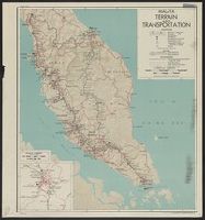
Description:
"No. 3151, 31 March 1944.", Includes ancillary map: "Kuala Lumpur and environs.", Index to vulnerable bridges and tunnels on verso., and Relief shown by shading.
Publisher:
Reproduction Branch, OSS,
Subject (Geographic):
Malaya--Maps
Subject (Name):
United States. Office of Strategic Services. Reproduction Branch
Subject (Topic):
Railroads--Malaysia--Malaya--Maps, Roads--Malaya--Maps, and Transportation--Malaysia--Malaya--Maps
Found in:
Beinecke Rare Book and Manuscript Library > Malaya : terrain and transportation / compiled and drawn in the Branch of Research and Analysis, OSS.
Creator:
Published / Created:
1913
Call Number:
848 1913A
Container / Volume:
BRBL_00631
Image Count:
2
Resource Type:
Maps, Atlases & Globes
Description:
"Index map showing areas covered by topographic maps, August 1913"., "Recent survey publications" text on verso., Includes inset of the Aleutian Islands and chart of "Maps of Alaska for sale by U.S. Geological Survey.", and Relief shown by hachures and spot heights.
Publisher:
U.S. Geological Survey,
Subject (Geographic):
Alaska--Maps
Found in:
Beinecke Rare Book and Manuscript Library > Map of Alaska : compiled chiefly from maps of the U.S. Geological Survey / engraved and printed by the U.S. Geological Survey ; Alfred H. Brooks, Geologist in charge, Division of Alaskan Mineral Resources.
Creator:
Published / Created:
1909
Call Number:
844fcm Y83 1909
Container / Volume:
BRBL_00615
Image Count:
1
Resource Type:
Maps, Atlases & Globes
Description:
Includes "Index map" and table of "Elevations of principal points." and Relief shown by contours and spot heights.
Publisher:
The Survey,
Subject (Geographic):
Yosemite Valley (Calif.)--Maps
Subject (Name):
Douglas, Edward Morehouse, 1855-1932, Marshall, R. B. (Robert Bradford), 1867-1949, and Matthes, François, 1874-1948
Found in:
Beinecke Rare Book and Manuscript Library > Map of Yosemite Valley, Mariposa County, California / U.S. Geological Survey, George Otis Smith, Director ; E.M. Douglas, geographer ; State of California, George C. Pardee, Govenor.
Creator:
Published / Created:
1843
Call Number:
73fab 1843
Container / Volume:
BRBL_00375B
Image Count:
1
Resource Type:
Maps, Atlases & Globes
Alternative Title:
Rouse's Point and its vicinity on Lake Champlain.
Description:
Backed with linen. and Includes text and map of "Rouse's Point and its vicinity on Lake Champlain."
Publisher:
Corps of Topl. Engineers,
Subject (Geographic):
Canada--Boundaries--United States--Maps and United States--Boundaries--Canada--Maps
Subject (Name):
Graham, J. D. (James Duncan), 1799-1865 and Graham, J. D.--(James Duncan),--1799-1865--Presentation inscription to Yale College
Found in:
Beinecke Rare Book and Manuscript Library > Map of the boundary lines between the United States and the adjacent British provinces : from the mouth of the River St. Croix to the intersection of the parallel of 45 degrees of north latitude with the River St. Lawrence near St. Regis.
Creator:
Published / Created:
1843
Call Number:
73fab 1843
Container / Volume:
BRBL_00375B
Image Count:
1
Resource Type:
Maps, Atlases & Globes
Alternative Title:
Rouse's Point and its vicinity on Lake Champlain.
Description:
"Map G no. 3." and Includes text and map of "Rouse's Point and its vicinity on Lake Champlain."
Publisher:
Corps of Topl. Engineers,
Subject (Geographic):
Canada--Boundaries--United States--Maps and United States--Boundaries--Canada--Maps
Found in:
Beinecke Rare Book and Manuscript Library > Map of the boundary lines between the United States and the adjacent British provinces : from the mouth of the River St. Croix to the intersection of the parallel of 45 degrees of north latitude with the River St. Lawrence near St. Regis.
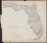
Creator:
Published / Created:
1866
Call Number:
792 1866
Container / Volume:
BRBL_00518
Image Count:
1
Resource Type:
Maps, Atlases & Globes
Description:
Imperfect.
Publisher:
General Land Office,
Subject (Geographic):
Florida--Maps and Florida--Maps--1866
Found in:
Beinecke Rare Book and Manuscript Library > Map of the state of Florida : showing the progress of the surveys accompanying [the] annual report of [the] Commissioner.
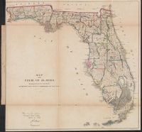
Published / Created:
1860
Call Number:
792 1860
Container / Volume:
BRBL_00518
Image Count:
1
Resource Type:
Maps, Atlases & Globes
Description:
Above neat line at right: Sen. ex: doc. no. 1 2d. sess: 36 Cong., Identifies counties with basic surveying grid superimposed over state., Lithographed by: J. Bien, 180 Broadway N.Y., Map approved by Francis L. Dancy, Surveyor General, October 1st, 1860., and Status of surveys identified by symbols.
Publisher:
U.S. Senate,
Subject (Geographic):
Florida--Maps
Subject (Name):
Bien, Julius, 1826-1909, Dancy, Francis L, and United States. Congress. Senate
Subject (Topic):
Maps shelf, Real property--Florida--Maps, and Real property--Maps
Found in:
Beinecke Rare Book and Manuscript Library > Map of the state of Florida showing the progress of the surveys accompanying annual report of the surveyor general for 1860.
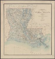
Creator:
Published / Created:
1896
Call Number:
795 1896
Container / Volume:
BRBL_00521
Image Count:
1
Resource Type:
Maps, Atlases & Globes
Alternative Title:
State of Louisiana
Description:
Prime meridians: Greenwich and Washington.
Publisher:
G.L.O.,
Subject (Geographic):
Louisiana--Maps
Subject (Name):
United States. General Land Office
Found in:
Beinecke Rare Book and Manuscript Library > Map of the state of Louisiana / compiled from the official records of the General Land Office and other sources under the direction of Harry King ; revised and drawn by Daniel O'Hare.
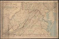
Creator:
Published / Created:
1863
Call Number:
783 1863B
Container / Volume:
BRBL_00509
Image Count:
1
Resource Type:
Maps, Atlases & Globes
Description:
Also covers Delaware, Maryland, West Virginia and parts of adjacent states., Includes table: Distances by railroads., and Relief shown by hachures.
Publisher:
The Office,
Subject (Geographic):
Delaware--Maps, Maryland--Maps, Virginia--Maps, and West Virginia--Maps
Subject (Name):
Bache, A. D. (Alexander Dallas), 1806-1867, Krebs, Charles G, and United States Coast Survey
Found in:
Beinecke Rare Book and Manuscript Library > Map of the state of Virginia / compiled from the best authorities and printed at the Coast Survey Office, A.D. Bache, supdt. ; compiled by W.L. Nicholson ; lith. by Chas. G. Krebs.
Branch:v1.61.8 ,Deployed:2024-06-20T11:14:55-04:00