Search
You Searched For
Search Results
- Published / Created:
- 1863-1864.
- Call Number:
- 75cea 1864
- Container / Volume:
- BRBL_00409
- Image Count:
- 2
- Resource Type:
- Maps, Atlases & Globes
- Found in:
- Beinecke Rare Book and Manuscript Library > Atlantic Coast of the United States (in four sheets).
- Creator:
- United States. General Land Office
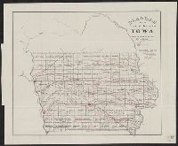
- Published / Created:
- 1866
- Call Number:
- 815fcm 1866
- Container / Volume:
- BRBL_00561
- Image Count:
- 1
- Resource Type:
- Maps, Atlases & Globes
- Found in:
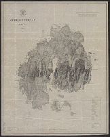
- Beinecke Rare Book and Manuscript Library > Diagram of the public surveys in Iowa.
- Published / Created:
- 1866
- Call Number:
- 75CKB 1870M
- Container / Volume:
- BRBL_00409
- Image Count:
- 1
- Resource Type:
- Maps, Atlases & Globes
- Found in:
- Beinecke Rare Book and Manuscript Library > Magnetic Declination : Isogonic lines for the year 1870 / Drawn by A. Lindenkohl ; Chas. G. Krebs, Lith.
- Creator:
- United States. General Land Office
- Published / Created:
- 1866
- Call Number:
- 792 1866
- Container / Volume:
- BRBL_00518
- Image Count:
- 1
- Resource Type:
- Maps, Atlases & Globes
- Found in:
- Beinecke Rare Book and Manuscript Library > Map of the state of Florida : showing the progress of the surveys accompanying [the] annual report of [the] Commissioner.
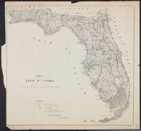
- Published / Created:
- 1860
- Call Number:
- 792 1860
- Container / Volume:
- BRBL_00518
- Image Count:
- 1
- Resource Type:
- Maps, Atlases & Globes
- Found in:
- Beinecke Rare Book and Manuscript Library > Map of the state of Florida showing the progress of the surveys accompanying annual report of the surveyor general for 1860.
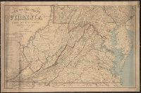
- Creator:
- Nicholson, W. L
- Published / Created:
- 1863
- Call Number:
- 783 1863B
- Container / Volume:
- BRBL_00509
- Image Count:
- 1
- Resource Type:
- Maps, Atlases & Globes
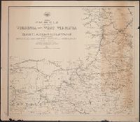
- Found in:
- Beinecke Rare Book and Manuscript Library > Map of the state of Virginia / compiled from the best authorities and printed at the Coast Survey Office, A.D. Bache, supdt. ; compiled by W.L. Nicholson ; lith. by Chas. G. Krebs.
- Creator:
- Nicholson, W. L
- Published / Created:
- [1863]
- Call Number:
- 754 1863B
- Container / Volume:
- BRBL_00416
- Image Count:
- 1
- Resource Type:
- Maps, Atlases & Globes
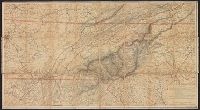
- Found in:
- Beinecke Rare Book and Manuscript Library > Mountain region of North Carolina and Tennessee / compiled by W.L. Nicholson & A. Lindenkohl, 1863 ; drawn by A. Lindenkohl ; H. Lindenkohl & Chas. G. Krebs, lith.
- Creator:
- Nicholson, W. L
- Published / Created:
- [1863]
- Call Number:
- 754 1863B
- Container / Volume:
- BRBL_00416
- Image Count:
- 1
- Resource Type:
- Maps, Atlases & Globes
- Found in:
- Beinecke Rare Book and Manuscript Library > Mountain region of North Carolina and Tennessee / compiled by W.L. Nicholson & A. Lindenkohl, 1863 ; drawn by A. Lindenkohl ; H. Lindenkohl & Chas. G. Krebs, lith.
- Creator:
- U.S. Coast and Geodetic Survey
- Published / Created:
- 1875
- Call Number:
- 761 M86 1875
- Container / Volume:
- BRBL_00448
- Image Count:
- 1
- Resource Type:
- Maps, Atlases & Globes
- Found in:
- Beinecke Rare Book and Manuscript Library > Mt. Desert Island Maine / C.P Patterson, Superintendent ; verified, J.E. Hilgard, Assistant in Charge of Office ; topography surveyed by J.W. Donn.
- Creator:
- United States. Post Office Dept
- Published / Created:
- 1874
- Call Number:
- 754GMD 1874
- Container / Volume:
- BRBL_00419
- Image Count:
- 2
- Resource Type:
- Maps, Atlases & Globes
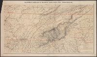
- Found in:
- Beinecke Rare Book and Manuscript Library > Preliminary post route map of the states of Virginia and West Virginia together with Maryland and Delaware, with adjacent parts of Pennsylvania, Ohio, Kentucky, Tennessee and North Carolina / designed and constructed under the orders of Postmaster General