Search
You Searched For
Search Results
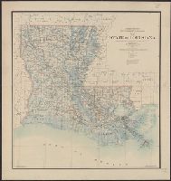
- Creator:
- O'Hare, Daniel
- Published / Created:
- 1896
- Call Number:
- 795 1896
- Container / Volume:
- BRBL_00521
- Image Count:
- 1
- Resource Type:
- Maps, Atlases & Globes
- Found in:
- Beinecke Rare Book and Manuscript Library > Map of the state of Louisiana / compiled from the official records of the General Land Office and other sources under the direction of Harry King ; revised and drawn by Daniel O'Hare.
- Creator:
- United States. Bureau of the Census
- Published / Created:
- 1934
- Call Number:
- 831fb 1930
- Container / Volume:
- BRBL_00581
- Image Count:
- 1
- Resource Type:
- Maps, Atlases & Globes
- Found in:
- Beinecke Rare Book and Manuscript Library > Montana, minor civil divisions : 1930 / Bureau of the Census.
- Creator:
- United States. Bureau of the Census
- Published / Created:
- 1934
- Call Number:
- 844fb 1930
- Container / Volume:
- BRBL_00614
- Image Count:
- 1
- Resource Type:
- Maps, Atlases & Globes
- Found in:
- Beinecke Rare Book and Manuscript Library > California : minor civil divisions / Bureau of the Census, 1930.
- Creator:
- Geological Survey (U.S.)
- Published / Created:
- 1909
- Call Number:
- 844fcm Y83 1909
- Container / Volume:
- BRBL_00615
- Image Count:
- 1
- Resource Type:
- Maps, Atlases & Globes
- Found in:
- Beinecke Rare Book and Manuscript Library > Map of Yosemite Valley, Mariposa County, California / U.S. Geological Survey, George Otis Smith, Director ; E.M. Douglas, geographer ; State of California, George C. Pardee, Govenor.
- Creator:
- Geological Survey (U.S.)
- Published / Created:
- 1910
- Call Number:
- 75cbf 1910
- Container / Volume:
- BRBL_00408
- Image Count:
- 1
- Resource Type:
- Maps, Atlases & Globes
- Found in:
- Beinecke Rare Book and Manuscript Library > United States relief map / compiled by Henry Gannett.
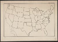
- Published / Created:
- 1920
- Call Number:
- 75ak 1920
- Container / Volume:
- BRBL_00407A
- Image Count:
- 1
- Resource Type:
- Maps, Atlases & Globes
- Found in:
- Beinecke Rare Book and Manuscript Library > [Outline Map of the United States] / engraved and printed by the U.S. Geological Survey.
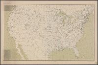
- Published / Created:
- 1909
- Call Number:
- 75ak 1909
- Container / Volume:
- BRBL_00407A
- Image Count:
- 1
- Resource Type:
- Maps, Atlases & Globes
- Found in:
- Beinecke Rare Book and Manuscript Library > United States Base Map / engraved by U.S.G.S.
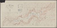
- Published / Created:
- 1891
- Call Number:
- 754 1891
- Container / Volume:
- BRBL_00417
- Image Count:
- 1
- Resource Type:
- Maps, Atlases & Globes
- Found in:
- Beinecke Rare Book and Manuscript Library > Progress of the surveys and resurveys between the St. Croix and Hudson Rivers.
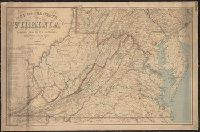
- Creator:
- Nicholson, W. L
- Published / Created:
- 1863
- Call Number:
- 783 1863B
- Container / Volume:
- BRBL_00509
- Image Count:
- 1
- Resource Type:
- Maps, Atlases & Globes
- Found in:
- Beinecke Rare Book and Manuscript Library > Map of the state of Virginia / compiled from the best authorities and printed at the Coast Survey Office, A.D. Bache, supdt. ; compiled by W.L. Nicholson ; lith. by Chas. G. Krebs.
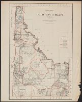
- Creator:
- United States. General Land Office
- Published / Created:
- 1883
- Call Number:
- 832 1883
- Container / Volume:
- BRBL_00582
- Image Count:
- 1
- Resource Type:
- Maps, Atlases & Globes
- Found in:
- Beinecke Rare Book and Manuscript Library > Territory of Idaho, 1883 / compiled from the official records of the General Land Office and other sources by G.P. Strum, Principal Draughtsman, Department of the Interior, General Land Office.