Skip to search
Skip to main content
Skip to first result
Search
You Searched For
Genre
Maps
Publication Place
A Paris
New Search
Search Results
Creator:
Published / Created:
1650.
Call Number:
90 1650
Image Count:
1
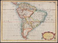
Alternative Title:
Ameriqve meridionale
Description:
BEIN 90 1650: Sheet measures 42 x 57 cm. Ms. no. on recto: 7[?]. Stamp on verso: Karpinski-von Wieser Map Collection., "Auec priuilege du Roy pour 20 ans"., and From Sanson's Cartes générales de toutes les parties du monde (1658).
Publisher:
Chez l'autheur, et chez Pierre Mariette, rue St. Iacques a l'Esperance ...
Subject (Geographic):
South America
Found in:
Beinecke Rare Book and Manuscript Library > Amerique meridionale
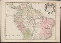
Creator:
Published / Created:
[1718]
Call Number:
90 1703A
Image Count:
1
Description:
Relief shown pictorially., Below cartouche: C.S., s., and Includes text.
Publisher:
Chéz l'auteur sur le Quai de I'Horloge a Aigle d'Or ...
Subject (Geographic):
South America
Found in:
Beinecke Rare Book and Manuscript Library > Carte de la Terre Ferme, du Perou, du Bresil : et du Pays des Amazones
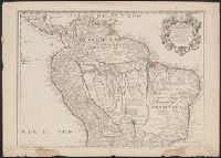
Creator:
Published / Created:
[1718]
Call Number:
90 1703
Image Count:
1
Description:
Relief shown pictorially., Below cartouche: C.S., s., and Includes text.
Publisher:
Chéz l'auteur sur le Quai de I'Horloge a Aigle d'Or ...
Subject (Geographic):
South America
Found in:
Beinecke Rare Book and Manuscript Library > Carte de la Terre Ferme, du Perou, du Bresil : et du Pays des Amazones
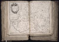
Creator:
Published / Created:
1646
Call Number:
1983 Folio 19
Collection Title:
[Atlas factice of 96 maps by Blaeu, Visscher, Jansson, Hondius and others]
Image Count:
1
Description:
Sheet measures 39 x 51.3 cm. Reinforced along lower edges with manuscript waste. No. 39 of 92 maps bound together.
Publisher:
Chez Pierre Mariette ...
Subject (Geographic):
Beauvais (France : Canton) --Maps --Early works to 1800
Collection Created:
[1556-1680]
Found in:
Beinecke Rare Book and Manuscript Library > Carte du Beauuaisis / A. Peyrounin fecit
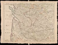
Creator:
Published / Created:
1714
Call Number:
BrSides Double Folio 2019 12
Image Count:
1
Resource Type:
Maps, Atlases & Globes
Description:
Relief shown pictorially., Shows forests, etc., and Watermark. Sheet measures 53 x 71 cm. Verso: "107" in manuscript.
Publisher:
Chez l'auteur, quay de l'Horloge
Subject (Geographic):
Dordogne (France)--Maps--Early works to 1800. and France, Southern--Maps--Early works to 1800.
Found in:
Beinecke Rare Book and Manuscript Library > Carte du Bourdelois, du Perigord et des provinces voisines / par G. del'Isle, Premier Géographe du Roy de l'Academie Rle. des Sciences.
Creator:
Published / Created:
1625
Call Number:
1983 Folio 19
Collection Title:
[Atlas factice of 96 maps by Blaeu, Visscher, Jansson, Hondius and others]
Image Count:
1
Description:
Imperfect: torn along fold, with some loss of text; bottom edge trimmed and repaired with printed waste. Sheet measures 55.3 x 37.3 cm. No. 16 of 92 maps bound together.
Publisher:
Chez Melchoir Tavernier ...
Subject (Geographic):
Valtellina (Italy) --Maps --Early works to 1800
Subject (Topic):
Thirty Years’ War, 1618-1648 --Campaigns --Italy --Valtellina --Maps
Found in:
Beinecke Rare Book and Manuscript Library > Carte et description generale de la Valtoline
Creator:
Published / Created:
[ca. 1655?]
Call Number:
1983 Folio 19
Collection Title:
[Atlas factice of 96 maps by Blaeu, Visscher, Jansson, Hondius and others]
Image Count:
1
Description:
BEIN 1983 Folio 19: Sheet measures 39.6 x 51.2 cm. Reinforced along edges with manuscript waste. No. 27 of 92 maps bound together.
Publisher:
Chez Iacques Honeruogt ...
Subject (Geographic):
Champagne-Ardenne (France) --Maps --Early works to 1800
Collection Created:
[1556-1680]
Found in:
Beinecke Rare Book and Manuscript Library > Champagne comitatus campania
Creator:
Published / Created:
1637
Call Number:
1983 Folio 19
Collection Title:
[Atlas factice of 96 maps by Blaeu, Visscher, Jansson, Hondius and others]
Image Count:
1
Description:
Reinforced along lower edges with manuscript waste. Sheet measures 38.9 x 51.3 cm. No. 32 of 92 maps bound together.
Publisher:
Chez Melchoir Tavernier ...
Subject (Geographic):
France --Maps --Early works to 1800
Collection Created:
[1556-1680]
Found in:
Beinecke Rare Book and Manuscript Library > Empire francois
Creator:
Published / Created:
[1656?]
Call Number:
1983 Folio 19
Collection Title:
[Atlas factice of 96 maps by Blaeu, Visscher, Jansson, Hondius and others]
Image Count:
1
Description:
Reinforced along edges with manuscript waste. Sheet measures 39 x 50.7 cm. No. 30 of 92 maps bound together.
Publisher:
Chez Pierre Mariette ...
Subject (Geographic):
Guadeloupe --Maps --Early works to 1800
Found in:
Beinecke Rare Book and Manuscript Library > Isle de la Guadeloupe : scituee a 16 degrez de lat. septentrionale / A. Peyrounin sculp
Creator:
Published / Created:
1700 [i.e. 1708]
Call Number:
90 1700
Image Count:
1
Description:
BEIN 90 1700: Sheet measures 54.9 x 74.8 cm. Ms. no. in upper left corner: 69., Relief shown pictorially., Prime meridian: Ferro., Imprint date from Tooley., "Je rends raison dans ma Nouvelle introduction a la geographie des changemens que jay faits sur cete carte.", Cartouche engraved by N. Guérard., and Includes notes.
Publisher:
Chéz l'Auteur sur le Quai de l'Horloge ...
Subject (Geographic):
South America
Found in:
Beinecke Rare Book and Manuscript Library > L'Amerique meridionale : dressée sur les observations de Mrs. de l'Academie Royale des Sciences & quelques autres, & sur les memoires les plus recens
Branch:v1.61.8 ,Deployed:2024-06-20T11:14:55-04:00