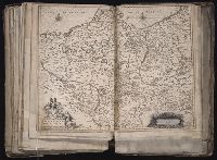
[Atlas factice of 96 maps by Blaeu, Visscher, Jansson, Hondius and others]
Image Count:
1
Description:
Imperfect: mutilated along fold, with some loss of text; bar scale cut out and replaced in ms. Reinforced along edges with printed waste. Sheet measures 39.1 x 50.4 cm. No. 78 of 92 maps bound together. and Numbered 84 [80, cancelled] on verso.
Publisher:
Excudebat Ioannes Ianssonius
Subject (Geographic):
Brandenburg (Germany : Landkreis) --Maps --Early works to 1800s, Mecklenburg-Vorpommern (Germany) --Maps --Early works to 1800, and Pomerania (Poland and Germany) --Maps --Early works to 1800
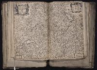
[Atlas factice of 96 maps by Blaeu, Visscher, Jansson, Hondius and others]
Image Count:
1
Description:
Imperfect: hole along folds, with some loss of text. Sheet measures 39.5 x 52 cm. Reinforced along edges with paper. No. 52 of 92 maps bound together. and Numbered 56 on verso.
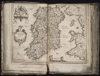
[Atlas factice of 96 maps by Blaeu, Visscher, Jansson, Hondius and others]
Image Count:
1
Description:
Imperfect: cartouche cut out and replaced in ms. with title Silesia Dvcatvs; edges reinforced with ms waste. Hand col. Sheet measures 38.8 x 51 cm. No. 69 of 92 maps bound together. and Numbered 74 [and 71, cancelled] on verso.
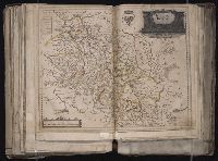
BEIN 1973 Folio 10: Sheet measures 51.8 x 61.2 cm. Bookplate of José M. Rodriguez. No. 54 of 63 maps bound together., Relief shown pictorially., Ferro meridian., and Bar scales given in milliaria Germanica communia and milliaria Gallica communia.