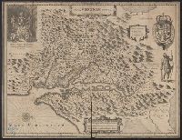
French text on verso, with running and caption title "Virginie," signature e, and catchword "ses.", From Jan Jansson's Nouvel atlas ... Amstelodami : Apud Ioannem Ianssonium, 1646-1649., Hendrik Hondius' derivative of John Smith's map of Virginia, 1612., and Ori
Publisher:
Ex officina Henrici Hondii,
Subject (Geographic):
Chesapeake Bay (Md. and Va.)--Maps--Early works to 1800, Maryland--Maps--Early works to 1800, and Virginia--Maps--Early works to 1800
Subject (Name):
Jansson, Jan, 1588-1664. Atlas novus. French and Smith, John, 1580-1631
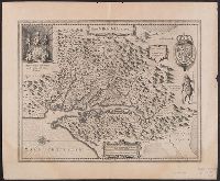
Hendrik Hondius' derivative of John Smith's map of Virginia, 1612., Oriented with north to the right., Relief shown pictorially., Sheet measures 47.6 x 57.7 cm. Franklin Collection no. 131 1633., and Verso in French, with running and caption title "Description de la Virginie," signatures 8O2, and catchword "peu".
Publisher:
Ex officina Henrici Hondii,
Subject (Geographic):
Chesapeake Bay (Md. and Va.)--Maps--Early works to 1800, Maryland--Maps--Early works to 1800, and Virginia--Maps--Early works to 1800
Subject (Name):
Jansson, Jan, 1588-1664. Atlas novus. French and Smith, John, 1580-1631