Skip to search
Skip to main content
Skip to first result
Search
You Searched For
Extent of Digitization
Completely digitized
Format
cartographic
Genre
Maps
Publication Place
Amstelodami :
New Search
Search Results
Published / Created:
[1630?]
Call Number:
364 1630
Container / Volume:
BRBL_00143
Image Count:
2
Resource Type:
Maps, Atlases & Globes
Description:
Verso: Text. and West central section of Germany.
Publisher:
Henricum Hondium,
Subject (Geographic):
North-Rhine-Westphalia (Germany)--Maps--Early works to 1800
Found in:
Beinecke Rare Book and Manuscript Library > Coloniesis Archiepiscopatus.
Creator:
Published / Created:
[approximately 1680?]
Call Number:
BrSides Double Folio 2019 64
Image Count:
1
Resource Type:
Maps, Atlases & Globes
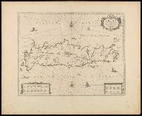
Description:
Manuscript number in upper left corner: 34., Relief shown pictorially., and Verso blank.
Publisher:
Sumptibus Ioannis Ianssonii,
Subject (Geographic):
Crete (Greece)--Maps--Early works to 1800.
Subject (Name):
Jansson, Jan, 1588-1664
Subject (Topic):
Geography, Ancient--Maps--Early works to 1800.
Found in:
Beinecke Rare Book and Manuscript Library > Creta Iovis magni, medio jacet insula ponto / ex conatibus geographicis Abrahami Ortelij.
Published / Created:
[1630?]
Call Number:
3615 1630
Container / Volume:
BRBL_00135
Image Count:
2
Resource Type:
Maps, Atlases & Globes
Description:
Lower Rhine, etc.
Publisher:
Henricum Hondium,
Subject (Geographic):
Rhine River--Maps--Early works to 1800
Found in:
Beinecke Rare Book and Manuscript Library > Descriptio Fluminum Rheni, Vahalis et Mosae ...
Published / Created:
[1640?]
Call Number:
3364 L62 1640
Container / Volume:
BRBL_00089
Image Count:
2
Resource Type:
Maps, Atlases & Globes
Description:
Preliminary record.
Publisher:
Henrici Hondii,
Subject (Geographic):
Liége (Belgium)--Maps--Early works to 1800
Found in:
Beinecke Rare Book and Manuscript Library > Diocesis Leodiensis Accurata Tabula.
Published / Created:
[1633?]
Call Number:
3826 C27 1633
Container / Volume:
BRBL_00176
Image Count:
2
Resource Type:
Maps, Atlases & Globes
Publisher:
Henrici Hondy
Subject (Geographic):
Flanders (France)--Maps--Early works to 1800
Found in:
Beinecke Rare Book and Manuscript Library > Ditio Casletana in Comitatu Flandriae Vulgo Cassel Ambacht.
Published / Created:
[1635?]
Call Number:
3655 1635
Container / Volume:
BRBL_00144
Image Count:
2
Resource Type:
Maps, Atlases & Globes
Publisher:
Henrici Hondy,
Subject (Geographic):
Schleswig-Holstein (Germany)--Maps--Early works to 1800
Found in:
Beinecke Rare Book and Manuscript Library > Ducatus Holsatiae Nova Tobula.
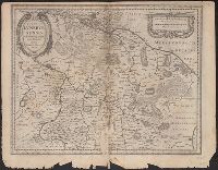
Creator:
Published / Created:
[1636]
Call Number:
3635 1640
Container / Volume:
BRBL_00142
Image Count:
2
Resource Type:
Maps, Atlases & Globes
Alternative Title:
Dvcatvs Lvnebvrgensis
Description:
Bar scales given in "milliaria Germanica communia," and "milliaria Gallica communia"., From Henricus Hondius and Joannes Janssonius's Atlas (English ed.), 1636., Imperfect: mutilated along fold, with some loss of text. Sheet measures 42.5 x 54.4 cm., and In Engl
Publisher:
Apud Joannem Janssonium,
Subject (Geographic):
Lower Saxony (Germany)--Maps--Early works to 1800
Subject (Name):
Hondius, Hendrik, 1597-1651. Atlas novus. English and Jansson, Jan, 1588-1664. Atlas novus. English
Found in:
Beinecke Rare Book and Manuscript Library > Ducatus Luneburgensis : adiacentium[que] regionum delineatio / auctore Iohanne Mellingero.
Creator:
Published / Created:
[1635]
Call Number:
3635 1660
Container / Volume:
BRBL_00142
Image Count:
2
Resource Type:
Maps, Atlases & Globes
Description:
Bar scales given in "milliaria Germanica communia," and "milliaria Gallica communia"., From Willem and Joan Blaeu's Theatrum orbis terrarum, 1635., In Latin on verso; with caption title "Luneburgum Ducatus" and signature S., Relief shown pictorially., and Sheet m
Publisher:
Guiljem. Blaeuw excudit,
Subject (Geographic):
Lower Saxony (Germany)--Maps--Early works to 1800
Subject (Name):
Blaeu, Joan, 1596-1673. Theatrum orbis terrarum and Blaeu, Willem Janszoon, 1571-1638. Theatrum orbis terrarum
Found in:
Beinecke Rare Book and Manuscript Library > Ducatus Luneburgensis [cartographic material] : adiacentium[que] regionum delineatio / auctore Iohanne Mellingero.
Published / Created:
[1630?]
Call Number:
364 1630B
Container / Volume:
BRBL_00143
Image Count:
2
Resource Type:
Maps, Atlases & Globes
Publisher:
Henricus Hondius,
Subject (Geographic):
North-Rhine-Westphalia (Germany)--Maps--Early works to 1800
Found in:
Beinecke Rare Book and Manuscript Library > Episcopatus Paderbornensis ... Joanne Gigante Ludense ...
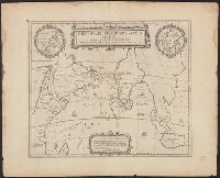
Creator:
Published / Created:
[ca. 1658]
Call Number:
29 1658
Container / Volume:
BRBL_00028
Image Count:
1
Resource Type:
Maps, Atlases & Globes
Alternative Title:
Erythraei sive Rvbri Maris periplvs
Description:
Appears in various editions of Jansson's Atlas Novus., Insets: Annonis Periplus; Hyper-Borei., and Ms. no. "49" in upper left hand corner. Sheet measures 51 x 62 cm
Publisher:
Sumptibus Ioannis Ianssonii,
Subject (Geographic):
Indian Ocean--Maps--Early works to 1800
Found in:
Beinecke Rare Book and Manuscript Library > Erythraei sive Rubri Maris periplus, olim ab Arriano descriptus, nunc vero ab Abrah. Ortelio ex eodem delineatus.
Branch:v1.64.3 ,Deployed:2024-09-25T10:53:04-04:00