Skip to search
Skip to main content
Skip to first result
Yale University Library
Ask Yale Library
Reserve Rooms
Places to Study
Research
Quicksearch
Search Library Catalog (Orbis)
Search Law Library Catalog (MORRIS)
Search Borrow Direct
Search WorldCat
Search Articles+
Search Digital Collections
Search Archives at Yale
Research Guides
Find Databases by Title
Find eJournals by Title
Guide to Using Special Collections
Services
Your Personal Librarian
Subject Specialists
Research Support and Workshops
Citation Tools
OverDrive: Popular Audio and eBooks
Get It @ Yale (Borrow Direct, Interlibrary Loan, Scan & Deliver)
Course Reserves
Off-Campus Access
EliScholar
OverDrive: Popular Audio and eBooks
Bass Media Equipment
Libraries & Collections
Arts Library
Bass Library
Beinecke Library
Classics Library
Divinity Library
Film Study Center
Fortunoff Archive
Humanities Collections
International Collections
Law Library
Lewis Walpole Library
Library Collection Services
Manuscripts & Archives
Map Collection
Marx Science & Social Science Library
Medical Library
Music Library
Sterling Library
Yale Center for British Art
Information & Policies
Library Hours
Departments & Staff
Borrowing & Circulation
Services for Persons with Disabilities
Copyright Basics
Scanning, Printing & Copying
Computers & Wireless
Library Policies
About the Library
Giving to the Library
Purchase Request
Working at the Library
Terms Governing Use of Materials
Search in
All Fields
Creator
Title
Call Number
Date
Subject
Orbis ID
Full Text
Description
Full text
search for
Search
Search
Advanced Search
Digital Collections
Search
You Searched For
Date
1760 - 1779
Genre
Maps
Resource Type
Maps, Atlases & Globes
Publication Place
Amstelodami :
Date Created
1760
to
1779
New Search
1
entry found
Sort
by relevance
relevance
Creator (A --> Z)
Creator (Z --> A)
Title (A --> Z)
Title (Z --> A)
Year (ascending)
Year (descending)
Number of results to display per page
9
per page
9
per page
30
per page
60
per page
99
per page
View results as:
List
List
Gallery
Gallery
Search Results
1.
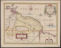
Guiana siue Amazonum regio.
Creator:
Valck, G. (Gerard), 1651 or 2-1726
Published / Created:
[17--]
Call Number:
906 1660
Container / Volume:
BRBL_00667
Image Count:
1
Resource Type:
Maps, Atlases & Globes
Alternative Title:
Gviana siue Amazonvm regio and Gviana sive Amazonvm regio
Description:
Bar scales in "Milliaria Germanica communia" and "Milliaria Gallica communia.", Hand col. Mounted on linen. Sheet measures 42.5 x 53.5 cm., and Relief shown pictorially.
Publisher:
Venditant Gerardus Valk et Petrus Schenk,
Subject (Geographic):
Guiana--Maps--Early works to 1800
Subject (Name):
Schenk, Peter, 1660-1718 or 1719
Found in:
Beinecke Rare Book and Manuscript Library
>
Guiana siue Amazonum regio.
Limit your search
Extent of Digitization
Completely digitized
1
Access
Public
1
Repository
Beinecke Rare Book and Manuscript Library
1
Format
cartographic
1
Genre
Maps
✖
[remove]
1
Resource Type
Maps, Atlases & Globes
✖
[remove]
1
Language
Latin
1
Creator
Valck, G. (Gerard), 1651 or 2-1726
1
Subject (Name)
Schenk, Peter, 1660-1718 or 1719
1
Publication Place
Amstelodami :
✖
[remove]
1
Date Created
1760
to
1779
✖
[remove]
1
1760
to
1761
1
1762
to
1763
1
1764
to
1765
1
1766
to
1767
1
1768
to
1769
1
1770
to
1771
1
1772
to
1773
1
1774
to
1775
1
1776
to
1777
1
1778
to
1779
1
Current results range from
1700
to
1799
Date Created range begin
Date Created range end
View larger »