Skip to search
Skip to main content
Skip to first result
Search
You Searched For
Language
Latin
Publication Place
Amstelodami :
New Search
Search Results
Published / Created:
[1635?]
Call Number:
441 1635
Container / Volume:
BRBL_00257
Image Count:
2
Resource Type:
Maps, Atlases & Globes
Description:
One copy in Color. and Verso: Text.
Publisher:
Sumpt. Henrici Hondii,
Subject (Geographic):
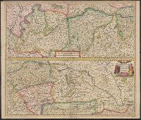
Danube River--Maps--Early works to 1800
Found in:
Beinecke Rare Book and Manuscript Library > Maximi Totius Europae Fluminis Danubu Cursus per Germaniam Hungariamque Nova Delineatio.
Published / Created:
[1635?]
Call Number:
441 1635
Container / Volume:
BRBL_00257
Image Count:
2
Resource Type:
Maps, Atlases & Globes
Description:
One copy in Color. and Verso: Text.
Publisher:
Sumpt. Henrici Hondii,
Subject (Geographic):
Danube River--Maps--Early works to 1800
Found in:
Beinecke Rare Book and Manuscript Library > Maximi Totius Europae Fluminis Danubu Cursus per Germaniam Hungariamque Nova Delineatio.
Published / Created:
[1635?]
Call Number:
3675 1635
Container / Volume:
BRBL_00145
Image Count:
1
Resource Type:
Maps, Atlases & Globes
Publisher:
Excudebat Ioannes Ianssonius,
Subject (Geographic):
Mecklenburg (Germany : Region)--Maps--Early works to 1800
Found in:
Beinecke Rare Book and Manuscript Library > Mecklenburg Ducatus Auctore Ioanne Laurenbergio.
Published / Created:
[1630?]
Call Number:
3675 1630
Container / Volume:
BRBL_00145
Image Count:
2
Resource Type:
Maps, Atlases & Globes
Description:
Verso: Text.
Publisher:
Joannes Janssonius,
Subject (Geographic):
Mecklenburg (Germany : Region)--Maps--Early works to 1800
Found in:
Beinecke Rare Book and Manuscript Library > Meklenburg Ducatus. Auctore Joanne Laurenbergio.
Published / Created:
[1640?]
Call Number:
3675 1640
Container / Volume:
BRBL_00145
Image Count:
2
Resource Type:
Maps, Atlases & Globes
Description:
Verso: Text.
Publisher:
G. Blaeuw,
Subject (Geographic):
Mecklenburg (Germany : Region)--Maps--Early works to 1800
Found in:
Beinecke Rare Book and Manuscript Library > Meklenburg Ducatus. Auctore Joanne Laurenbergio. S. Rogiers Sculp.
Published / Created:
[1630?]
Call Number:
3635 1630
Container / Volume:
BRBL_00141
Image Count:
2
Resource Type:
Maps, Atlases & Globes
Description:
Verso: Text.
Publisher:
Joannem Janssonium,
Subject (Geographic):
Lower Saxony (Germany)--Maps--Early works to 1800
Found in:
Beinecke Rare Book and Manuscript Library > Monasteriensis Episcopatus.
Published / Created:
[1630?]
Call Number:
3645 1630
Container / Volume:
BRBL_00144
Image Count:
2
Resource Type:
Maps, Atlases & Globes
Publisher:
Henricus Hondius,
Subject (Geographic):
Rhineland-Palatinate (Germany)--Maps--Early works to 1800
Found in:
Beinecke Rare Book and Manuscript Library > Nassouia Comitatus.
Published / Created:
[1640?]
Call Number:
3645 1640
Container / Volume:
BRBL_00144
Image Count:
2
Resource Type:
Maps, Atlases & Globes
Description:
Verso: Text.
Publisher:
G. Blaeuw,
Subject (Geographic):
Rhineland-Palatinate (Germany)--Maps--Early works to 1800
Found in:
Beinecke Rare Book and Manuscript Library > Nassouia Comitatus. S. Rogiers Sculpsit.
Creator:
Published / Created:
[1649]
Call Number:
18 1650
Container / Volume:
BRBL_00681
Image Count:
2
Resource Type:
Maps, Atlases & Globes
Alternative Title:
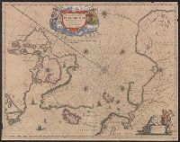
Nova et accvrata Poli Arctici et terrarum circum Iacentium descriptio
Description:
Cross collection no. 51., From: Nouvel atlas, ou, Theatre du Monde ... Amstelodami : Apud Ioannem Ianssonium, 1649., In Latin, with French text on verso; running title "Description"; caption title "Le pole Arctique avec les regions situees dessous"; sig. P., and Includes ill. and decorative cartouche.
Publisher:
Apud Ioannem Ianssonium,
Subject (Geographic):
Arctic Regions--Maps--Early works to 1800
Subject (Name):
Jansson, Jan, 1588-1664. Nouvel atlas, ou, theatre du monde
Found in:
Beinecke Rare Book and Manuscript Library > Noua et accurata Poli Arctici et terrarum circum Iacentium descriptio.
Published / Created:
[1625?]
Call Number:
3627 Sw12 1625
Container / Volume:
BRBL_00140
Image Count:
2
Resource Type:
Maps, Atlases & Globes
Description:
Verso: Text.
Publisher:
Henricum Hondium,
Subject (Geographic):
Swabia (Germany)--Maps--Early works to 1800
Found in:
Beinecke Rare Book and Manuscript Library > Nova Alemanniae sine Sueviae Superioris Tabula.
Branch:v1.61.8 ,Deployed:2024-06-20T11:14:46-04:00