Skip to search
Skip to main content
Skip to first result
Search
You Searched For
Genre
Maps
Genre
Maps in books
Publication Place
Amsterdam
Subject (Geographic)
Europe --Maps --Early works to 1800
New Search
Search Results
Creator:
Published / Created:
ca. 1684
Call Number:
Folio 469
Collection Title:
[Atlas factice of 13 maps by Nicolaes Visscher I, Nicolaes Visscher II, Guillaume Sanson, and
Image Count:
1
Publisher:
Nicolaes Visscher
Subject (Geographic):
Benelux countries --Maps --Early works to 1800 and Europe --Maps --Early works to 1800
Subject (Topic):
Atlases, Dutch --Early works to 1800
Collection Created:
1677-1692
Found in:
Beinecke Rare Book and Manuscript Library > Belgium Foederatum / [cartographic material] / emendate auctum et novissime editum, per Nicolaum Visscher
Creator:
Published / Created:
ca. 1684
Call Number:
Folio 469
Collection Title:
[Atlas factice of 13 maps by Nicolaes Visscher I, Nicolaes Visscher II, Guillaume Sanson, and
Image Count:
1
Publisher:
Nicolaes Visscher
Subject (Geographic):
Europe --Maps --Early works to 1800 and Hainaut (Belgium) --Maps --Early works to 1800
Subject (Topic):
Atlases, Dutch --Early works to 1800
Collection Created:
1677-1692
Found in:
Beinecke Rare Book and Manuscript Library > Comitatus Hannoniae et Archiepiscopatus Cameracensis tabula / [cartographic material] / per Nicolaum Visscher
Creator:
Published / Created:
ca. 1680
Call Number:
Folio 469
Collection Title:
[Atlas factice of 13 maps by Nicolaes Visscher I, Nicolaes Visscher II, Guillaume Sanson, and
Image Count:
1
Publisher:
Justus Danckerts
Subject (Geographic):
Europe --Maps --Early works to 1800 and Netherlands --Maps --Early works to 1800
Subject (Topic):
Atlases, Dutch --Early works to 1800
Collection Created:
1677-1692
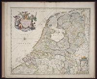
Found in:
Beinecke Rare Book and Manuscript Library > Comitatus Hollandiae tabula / [cartographic material] / pluribus locis recens emendata a Iusto Danckerts
Creator:
Published / Created:
ca. 1684
Call Number:
Folio 469
Collection Title:
[Atlas factice of 13 maps by Nicolaes Visscher I, Nicolaes Visscher II, Guillaume Sanson, and
Image Count:
1
Publisher:
Nicolaes Visscher
Subject (Geographic):
Europe --Maps --Early works to 1800 and Namur (County) --Maps --Early works to 1800
Subject (Topic):
Atlases, Dutch --Early works to 1800
Collection Created:
1677-1692
Found in:
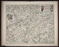
Beinecke Rare Book and Manuscript Library > Comitatus Namurci / [cartographic material] / emendata delineatio nuperrime in lucem edita per Nicolaum Visscher
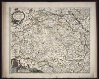
Creator:
Published / Created:
ca. 1684
Call Number:
Folio 469
Collection Title:
[Atlas factice of 13 maps by Nicolaes Visscher I, Nicolaes Visscher II, Guillaume Sanson, and
Image Count:
2
Publisher:
Nicolaes Visscher
Subject (Geographic):
Europe --Maps --Early works to 1800 and Luxembourg --Maps --Early works to 1800
Subject (Topic):
Atlases, Dutch --Early works to 1800
Collection Created:
1677-1692
Found in:
Beinecke Rare Book and Manuscript Library > Ducatus Lutzenburgi novissima et accuratissima delineatio / [cartographic material] / per Nic. Visscher
Creator:
Published / Created:
ca. 1684
Call Number:
Folio 469
Collection Title:
[Atlas factice of 13 maps by Nicolaes Visscher I, Nicolaes Visscher II, Guillaume Sanson, and
Image Count:
1
Publisher:
Nicolaes Visscher
Subject (Geographic):
Belgium --Maps --Early works to 1800, Europe --Maps --Early works to 1800, and France, Northern --Maps --Early works to 1800
Subject (Topic):
Atlases, Dutch --Early works to 1800
Collection Created:
1677-1692
Found in:
Beinecke Rare Book and Manuscript Library > Flandriae comitatus / [cartographic material] / accuratissima descriptio edita per Nicolaum Visscher
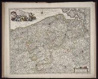
Creator:
Published / Created:
ca. 1684
Call Number:
Folio 469
Collection Title:
[Atlas factice of 13 maps by Nicolaes Visscher I, Nicolaes Visscher II, Guillaume Sanson, and
Image Count:
1
Publisher:
Nicolaes Visscher
Subject (Geographic):
Artois (France) --Maps --Early works to 1800, Europe --Maps --Early works to 1800, and Pas-de-Calais (France) --Maps --Early works to 1800
Subject (Topic):
Atlases, Dutch --Early works to 1800
Found in:
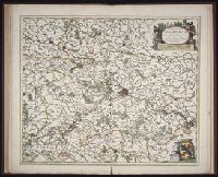
Beinecke Rare Book and Manuscript Library > Geographica Artesiae comitatus tabula / [cartographic material] / per Nicolaum Visscher edita
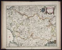
Creator:
Published / Created:
ca. 1677
Call Number:
Folio 469
Collection Title:
[Atlas factice of 13 maps by Nicolaes Visscher I, Nicolaes Visscher II, Guillaume Sanson, and
Image Count:
1
Publisher:
Nicolaes Visscher
Subject (Geographic):
Europe --Maps --Early works to 1800 and Liege (Belgium : Province) --Maps --Early works to 1800
Subject (Topic):
Atlases, Dutch --Early works to 1800
Collection Created:
1677-1692
Found in:
Beinecke Rare Book and Manuscript Library > Leodiensis Episcopatus in omnes subjacentes provincias distincte divisus / [cartographic material] / per Nicolaum Visscher, Amt. Bat., cum privilegio Ordinum Hollandiae et West-Frisie
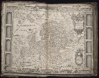
Creator:
Published / Created:
ao. 1652
Call Number:
1983 Folio 19
Collection Title:
[Atlas factice of 96 maps by Blaeu, Visscher, Jansson, Hondius and others]
Image Count:
1
Description:
Imperfect: torn along fold, with some loss of text; portions of decorative border cut or torn and repaired, with missing sections replicated in ms.; tears repaired. Sheet measures 45.3 x 56.4 cm. No. 2 of 92 maps bound together.
Publisher:
C.J. Visscher ex
Subject (Geographic):
Europe --Maps --Early works to 1800
Collection Created:
[1556-1680]
Found in:
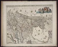
Beinecke Rare Book and Manuscript Library > Nova Europae descriptio / auctore N. Visscher
Creator:
Published / Created:
[ca. 1684]
Call Number:
Folio 469
Collection Title:
[Atlas factice of 13 maps by Nicolaes Visscher I, Nicolaes Visscher II, Guillaume Sanson, and
Image Count:
1
Alternative Title:
Novissima et accuratissima septendecim provinciarum Germanae Inferiores delineatio
Publisher:
Ex officina Nicolaes Visscher ...
Subject (Geographic):
Benelux countries --Maps --Early works to 1800 and Europe --Maps --Early works to 1800
Subject (Topic):
Atlases, Dutch --Early works to 1800
Collection Created:
1677-1692
Found in:
Beinecke Rare Book and Manuscript Library > Novissima et accuratissima XVII provinciarum Germanae Inferiores delineatio [cartographic material]
Branch:v1.61.6 ,Deployed:2024-06-12T09:55:19-04:00