Neptune françois, ou, Atlas nouveau des cartes marines.
Description:
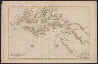
Appears in: Le Neptune françois, ou, Atlas nouveau des cartes marines, various eds., Covers coasts of Virginia, Maryland, Delaware, New, Described in Coolie Verner's Printed maps of Virginia, 1590-1800, p. 402., Nautical chart., and Oriented with north to right.
Publisher:
Chez P. Mortier,
Subject (Geographic):
Middle Atlantic States--Maps--Early works to 1800
Subject (Name):
Mortier, Pierre
Subject (Topic):
Coasts, Coasts--Delaware--Maps--Early works to 1800, Coasts--Maryland--Maps--Early works to 1800, Coasts--New Jersey--Maps--Early works to 1800, and Nautical charts--Chesapeake Bay (Md. and Va.)--Early works to 1800
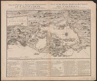
Cross Collection no. 334., In French and Dutch., Includes a numbered key indicating the locations of the French and English fleets during the raid on Cartagena in 1697., Ms. no. on verso: No. 103., and Oriented with north towards up
Publisher:
Chez Covens et Mortier,
Subject (Geographic):
Cartagena (Colombia)--History--Siege, 1741--Maps and Cartagena (Colombia)--Maps--Early works to 1800