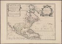
Originally L'Isle lived at the Rue des Canettes prez de St. Sulpice, in Paris; and the first issue of this map bears that location. About 1708 he moved to the address given on this map. Therefore, this map must have been issued in 1708 or later. See Map C
Publisher:
chez L. Renard Libraire, prz de la Bourse, and Chez l'Autheur sur le Quai de l'Horloge à la Courne. de Diamans ;
Subject (Geographic):
North America--Maps--Early works to 1800
Subject (Name):
Guérard, Nicolas, ca. 1648-1719 and Renard, Louis, b. ca. 1678
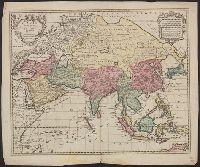
America Septentrionales in suas praecipus partes divisa, ad usum serenissimi Burgundiae Ducis
Description:
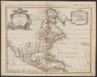
"Avec privilege.", Appeared in various eds. of Cóvens et Mortier's Atlas, Described in Mercator's world. Vol. 6, no. 6. Sept./Oct. 2001, p. 30., Includes eight bar scales., and Watermark. Stamp on verso: Yale, Horace Brown, 1900S. Sheet measures 50.5 x 63.2 cm.
For history of map and earlier states, see P.D. Burden's Mapping of North America, no. 245., Includes "Avertissement.", Ms. title on verso. Label with ms. no. on verso: 101/63. Sheet measures 54.8 x 63 cm. Cross collection no. 144., and Relief shown pictorially.
Publisher:
Chez R. & J. Ottens, geogrâphes dan le Kalverstraat au Carte du Monde,
Busch, Georg Paul, d. 1756, engraver Cóvens et Mortier, printer Gundling, Jacob Paul, Freiherr von, 1673-1731 L'Isle, Guillaume de, 1675-1726. Atlas nouveau
Published / Created:
[1742]
Call Number:
1977 Folio 177
Image Count:
2
Resource Type:
Maps, Atlases & Globes
Alternative Title:
Nova Electoratus Brandenburgici tabula edita per I.P. Fr. von Gundling
Description:
"G.P. Busch sculpsit"., From Guillaume de L'Isle's Atlas nouveau., Includes illustrated cartouches., Prime meridian: Ferro., Relief shown pictorially., Shows settlements, universities, roads, forests, rivers, etc., and Title in ms. on verso. Stamp on verso: 305. Sheet measures 54.2 x 67.5 cm. No. 28 of 34 maps bound together.
Publisher:
Bey Johannes Covens und Cornelius Mortier,
Subject (Geographic):
Brandenburg (Germany)--Maps--Early works to 1800 and Poland--Maps--Early works to 1800