Skip to search
Skip to main content
Skip to first result
Search
You Searched For
Access
Public
Format
cartographic
Publication Place
Berlin :
New Search
Search Results
Creator:
Published / Created:
1909
Call Number:
26911 1909A
Container / Volume:
BRBL_00023A
Image Count:
1
Resource Type:
Maps, Atlases & Globes
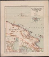
Alternative Title:
Deutsch-Neuguinea (westliches Blatt)
Publisher:
Reichs-Kolonialamt, Dietrich Reimer (Ernst Vohsen),
Subject (Geographic):
Papua New Guinea--Maps
Subject (Name):
Moisel, Max
Found in:
Beinecke Rare Book and Manuscript Library > Deutsch-Neuguinea (Kaiser-Wilhelmsland u. Bismarck-Archipel) / bearbeitet v. P. Sprigade u. M. Moisel.
Creator:
Published / Created:
[1905?]
Call Number:
634 1905
Container / Volume:
BRBL_00336
Image Count:
1
Resource Type:
Maps, Atlases & Globes
Description:
Includes index and inset of "Die Südhälfte von Afrika, zur Übersicht der Beziehungen Deutsch-Ostafrikas zu den übrigen deutsch-afrikanischen Kolonien.", Relief shown by shading and spot heights., and Shows mineral resources.
Publisher:
D. Reimer (E. Vohsen),
Subject (Geographic):
Tanzania--Maps
Subject (Topic):
Mines and mineral resources--Tanzania--Maps
Found in:
Beinecke Rare Book and Manuscript Library > Deutsch-Ostafrika / Neubearbeitung von Max Meisel.
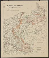
Published / Created:
1919
Call Number:
36ef 1919
Container / Volume:
BRBL_00127
Image Count:
1
Resource Type:
Maps, Atlases & Globes
Publisher:
Preuss,
Subject (Geographic):
Europe, Eastern--Maps
Subject (Topic):
German Language--Europe, Eastern--Maps
Found in:
Beinecke Rare Book and Manuscript Library > Deutsches Sprachgebeit : an der Friedensvertragslinie.
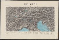
Published / Created:
[1870]
Call Number:
304 1870
Container / Volume:
BRBL_00033
Image Count:
1
Resource Type:
Maps, Atlases & Globes
Description:
Index to mountain heights in margin.
Publisher:
Stich v. J. Straube,
Subject (Geographic):
Alps--Maps and Europe, Central--Maps
Found in:
Beinecke Rare Book and Manuscript Library > Die Alpen / Photolithographie Druck, Verlag u. Eigenthum v. Kellner u. Giesemann.
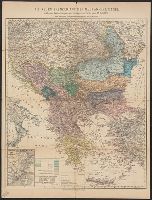
Creator:
Published / Created:
1878
Call Number:
44FD 1878
Container / Volume:
BRBL_00257
Image Count:
2
Resource Type:
Maps, Atlases & Globes
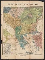
Description:
Inset: Constantinopel und der Bosporus.
Publisher:
Dietrich Reimer,
Subject (Geographic):
Balkan Peninsula--Maps
Found in:
Beinecke Rare Book and Manuscript Library > Die neuen Grenzen auf der Balkan - Halbinsel [cartographic material] : nach den Bestimmungen des Vertrags von Berlin vom 13. Juli 1878 / Nach amtlichen Quellen zusammengestellt von H. Kiepert.
Creator:
Published / Created:
1878
Call Number:
44FD 1878
Container / Volume:
BRBL_00257
Image Count:
2
Resource Type:
Maps, Atlases & Globes
Description:
Inset: Constantinopel und der Bosporus.
Publisher:
Dietrich Reimer,
Subject (Geographic):
Balkan Peninsula--Maps
Found in:
Beinecke Rare Book and Manuscript Library > Die neuen Grenzen auf der Balkan - Halbinsel [cartographic material] : nach den Bestimmungen des Vertrags von Berlin vom 13. Juli 1878 / Nach amtlichen Quellen zusammengestellt von H. Kiepert.
Creator:
Published / Created:
1888
Call Number:
304 1888
Container / Volume:
BRBL_00034
Image Count:
1
Resource Type:
Maps, Atlases & Globes
Publisher:
Sich und Druck,
Subject (Geographic):
Europe, Central--Maps
Found in:
Beinecke Rare Book and Manuscript Library > Eisenbahn und Reise Karte von Mittel-Europa ... / W. Liebenow.
Published / Created:
[1940?]
Call Number:
319 1940
Container / Volume:
BRBL_00040
Image Count:
2
Resource Type:
Maps, Atlases & Globes
Description:
Verso: Countries around the North Sea, World showing colonies etc.
Publisher:
Georg Westermann,
Subject (Geographic):
British Isles--Maps
Found in:
Beinecke Rare Book and Manuscript Library > England. Mit Genehmigung de Bibliographischen Instituts in Leipzig.
Creator:
Published / Created:
1876
Call Number:
44ED 1876
Container / Volume:
BRBL_00257
Image Count:
1
Resource Type:
Maps, Atlases & Globes
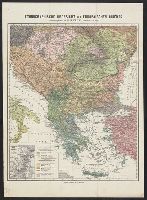
Description:
Inset: Constantinopel und der Bosporus, 1:300,000.
Publisher:
D. Reimer,
Subject (Geographic):
Balkan Peninsula--Maps
Subject (Topic):
Balkan Peninsula--Languages
Found in:
Beinecke Rare Book and Manuscript Library > Ethnographische Übersicht des Europäischen Orients / zusammengestellt von H. Kiepert, Berlin im Mai 1876.
Creator:
Published / Created:
1876
Call Number:
44ED 1876
Container / Volume:
BRBL_00257
Image Count:
1
Resource Type:
Maps, Atlases & Globes
Description:
Inset: Constantinopel und der Bosporus, 1:300,000.
Publisher:
D. Reimer,
Subject (Geographic):
Balkan Peninsula--Maps
Subject (Topic):
Balkan Peninsula--Languages
Found in:
Beinecke Rare Book and Manuscript Library > Ethnographische Übersicht des Europäischen Orients / zusammengestellt von H. Kiepert, Berlin im Mai 1876.
Branch:v1.64.0 ,Deployed:2024-09-11T10:25:15-04:00