Skip to search
Skip to main content
Skip to first result
Search
You Searched For
Extent of Digitization
Completely digitized
Format
cartographic
Language
English
Publication Place
Boston :
New Search
Search Results
Published / Created:
1863
Call Number:
774AM G33 1863
Container / Volume:
BRBL_00500
Image Count:
1
Resource Type:
Maps, Atlases & Globes
Publisher:
Jno. B. Bachelder ,
Subject (Geographic):
Gettysburg Battlefield (Pennsylvania)--Maps
Found in:
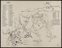
Beinecke Rare Book and Manuscript Library > Gettysburg Battlefield : Battle fought at Gettyburg Pa. on July 1st 2d 3d byt the Federal and Confederate armies.
Creator:
Published / Created:
[1843]
Call Number:
BrSides 2019 109
Image Count:
2
Resource Type:
Maps, Atlases & Globes
Description:
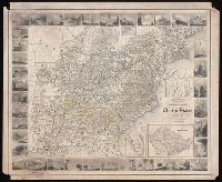
Imperfect: chipped. Autograph on verso: J.H. Chickering, Jan. 29, 1850., Includes inset maps: N. part of Michigan; N. part of Maine; Plan of Washington; S. part of Florida., Map surrounded by thirty-eight vingettes., and Prime meridian: Washington, D.C.
Publisher:
[Goodyear?],
Subject (Geographic):
United States--Maps.
Subject (Name):
Chickering, J. H.--Autograph.
Subject (Topic):
Counties--United States--Maps.
Found in:
Beinecke Rare Book and Manuscript Library > Goodyear's miniature county map of the United States / engraved by J.H. Goldthwait.
Creator:
Published / Created:
1907
Call Number:
802 M31 1907
Container / Volume:
BRBL_00542
Image Count:
1
Resource Type:
Maps, Atlases & Globes
Description:
"From former surveys, with recent additions." and Includes index and table of distances.
Publisher:
Geo. H. Walker & Co.,
Subject (Geographic):
Mammoth Cave (Ky.)--Maps
Subject (Name):
Geo. H. Walker & Co
Subject (Topic):
Caves--Kentucky--Mammoth Cave--Maps
Found in:
Beinecke Rare Book and Manuscript Library > Guide map of the Mammoth Cave, Kentucky / drawn by Horace C. Hovey.
Published / Created:
1893
Call Number:
766 H26 1893
Container / Volume:
BRBL_00468
Image Count:
1
Resource Type:
Maps, Atlases & Globes
Publisher:
Geo. H. Walker & Co.,
Subject (Geographic):
Hartford (Conn)--Maps
Found in:
Beinecke Rare Book and Manuscript Library > Hartford [County].
Published / Created:
[1877?]
Call Number:
32am L84 1877
Container / Volume:
BRBL_00075
Image Count:
1
Resource Type:
Maps, Atlases & Globes
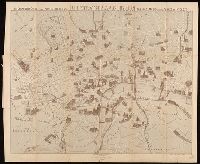
Alternative Title:
Stranger's guide to the public buildings, theatres, music halls, & all places of interest and Stranger's guide to the public buildings, theatres, music halls, and all places of interest
Description:
Manuscript note on verso, "From folder entitled: Barlett's illustrated map of London & Paris ..." and Pictorial map.
Publisher:
George H. Young,
Subject (Geographic):
London (England)--Maps.
Found in:
Beinecke Rare Book and Manuscript Library > Illustrated map of London, or, stranger's guide to the public buildings, theatres, music halls, & all places of interest.
Published / Created:
1893
Call Number:
766 1893J
Container / Volume:
BRBL_00467
Image Count:
2
Resource Type:
Maps, Atlases & Globes
Description:
2 sheets and Contoured.
Publisher:
GH Walker & Co.,
Subject (Geographic):
Connecticut--Maps
Found in:
Beinecke Rare Book and Manuscript Library > Latest map and index of Connecticut.
Published / Created:
1893
Call Number:
766 1893W
Container / Volume:
BRBL_00467
Image Count:
1
Resource Type:
Maps, Atlases & Globes
Publisher:
GH Walker & Co.,
Subject (Geographic):
Connecticut--Maps
Found in:
Beinecke Rare Book and Manuscript Library > Latest map and index of Eastern Connecticut.
Creator:
Published / Created:
[1854]
Call Number:
825gmb L435 1854
Container / Volume:
BRBL_00576
Image Count:
1
Resource Type:
Maps, Atlases & Globes
Description:
Relief shown by hachures.
Publisher:
L.H. Bradford & Co. Lith.,
Subject (Geographic):
Lawrence (Kan.)--Maps
Subject (Name):
L.H. Bradford & Co
Found in:
Beinecke Rare Book and Manuscript Library > Lawrence City, Kanzas Territory / surveyed Oct. 1854 by A.D. Searl.
Creator:
Published / Created:
1859
Call Number:
762AM W588 1859
Container / Volume:
BRBL_00451
Image Count:
1
Resource Type:
Maps, Atlases & Globes
Description:
"Engraved by S.E. Brown.", Includes tables of distances between stations along railroad lines., Inset: Map showing line of Grand Trunk Railway of Canadas and United States., Pictorial map of the White Mountains with four vignette views., and Relief shown pictoria
Publisher:
Electrotyped by Dillingham & Bragg,
Found in:
Beinecke Rare Book and Manuscript Library > Leavitt's map with views of the White Mountains, New Hampshire ; 1859 / drawn by Franklin Leavitt, Lancaster, N.H.
Published / Created:
1893
Call Number:
766 L71 1893
Container / Volume:
BRBL_00469
Image Count:
1
Resource Type:
Maps, Atlases & Globes
Description:
Catalogue card reads "Feo. H. Walker & Co."
Publisher:
Geo. H. Walker Co. ,
Subject (Geographic):
Litchfield County (Conn.)--Maps
Found in:
Beinecke Rare Book and Manuscript Library > Litchfield County.
Branch:v1.61.8 ,Deployed:2024-06-20T11:14:55-04:00