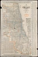
Chicago, Clason's double indexed map. and Green guide series
Description:
"Copyrighted by the C.M. Co.", Imperfect. Mutilated with no loss of text. Torn along folds., Indexed., and Insets: Diagram illustrating Chicago street numbering system and showing use of marginal key -- Map of Chicago business district.
"Engraved and indexed for use with the Rand McNally commercial atlas and marketing guide.", Date inferred from 1950 population table of counties., and Indexed.
Publisher:
The Company,
Subject (Geographic):
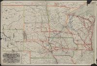
Colorado--Administrative and political divisions--Maps and Colorado--Maps
In lower right: 534506. and Includes indexes, and maps of "Kings Canyon and Sequoia national parks," "Yosemite National Park," and "Fresno, Stockton, Yosemite, Kings Canyon, and Sequoia Region, Calif.," and ill. on verso.
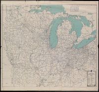
"Should be used simultaneously with corresponding detailed directions published in the Automobile blue books.", Includes index to adjoining sheets., and Map of the Mid-Atlantic states includes inset of the Kentucky/West Virginia/Virginia/North Carolina/Tennesse border; map of the Middle West includes inset of the Minnesota/Canada border.
Publisher:
Automobile Blue Books,
Subject (Geographic):
Middle Atlantic States--Maps and Middle West--Maps
"Prepared under the direction of the State Free Public Library Commission.", Printed on the Public Service Commission Map of the State of Vermont., and Relief shown by hachures.
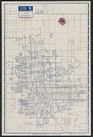
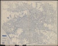
Copyright: Rand McNally & Company., In lower right: Y.3897., Includes inset of "Pacific Palisades.", and Indexes, "Los Angeles and vicinity (recreational map)," (scale [ca. 1:323,136]), and ill. on verso.
Publisher:
Rand McNally & Co.,
Subject (Geographic):
Los Angeles (Calif.)--Maps and Los Angeles Metropolitan Area (Calif.)--Maps
Subject (Name):
Union Oil Company of California
Subject (Topic):
Roads--California--Los Angeles Metropolitan Area--Maps and Streets--California--Los Angeles--Maps
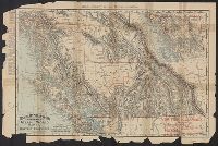
Rand, McNally & Co.'s indexed indexed atlas of the world map of British Columbia
Description:
"British Columbia Railroads"--Lower right corner., "Copyright, 1895, by Rand, McNally & Co.", "Rand, McNally & Co.'s New Business Atlas Map of British Columbia.", Inset: Northern part of British Columbi, and Railroads; settlements; mining districts and divisions.