Skip to search
Skip to main content
Skip to first result
Search
You Searched For
Format
cartographic
Language
English
Creator
Rand McNally and Company
Subject (Topic)
Railroads--Illinois--Maps.
Publication Place
Chicago :
New Search
Search Results
Creator:
Published / Created:
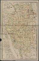
1897
Call Number:
806 1898
Container / Volume:
BRBL_00547
Image Count:
1
Resource Type:
Maps, Atlases & Globes
Description:
Inset: Map of Chicago showing railroad system.
Publisher:
Rand McNally & Co.,
Subject (Name):
Illinois. Railroad and Warehouse Commission
Subject (Topic):
Railroads--Illinois--Maps.
Found in:
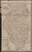
Beinecke Rare Book and Manuscript Library > Railroad map of Illinois / prepared under the direction of, and presented by Cicero J. Lindly, Chas. S. Rannells, and Jos. E. Bidwill, Railroad and Warehouse Commissioners.
Creator:
Published / Created:
1878
Call Number:
806 1878R
Container / Volume:
BRBL_00547
Image Count:
1
Resource Type:
Maps, Atlases & Globes
Description:
Imperfect: chipped, with some loss of text., Insets: Vicinity of Davenport & Rock Island -- Chicago and vicinity., and Prime meridians: Washington and Greenwich.
Publisher:
Rand McNally & Co.,
Subject (Name):
Illinois. Railroad and Warehouse Commission
Subject (Topic):
Railroads--Illinois--Maps.
Found in:
Beinecke Rare Book and Manuscript Library > Railroad map of Illinois : prepared for the 1878 Report of Railroad and Warehouse Commissioners / by Rand, McNally & Co.
Branch:v1.61.6 ,Deployed:2024-06-12T09:55:37-04:00