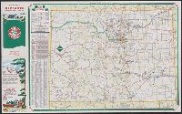
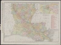
"9-5650-5" on Colorado map and "9-574620V-4" on Denver map., Denver street map -- Colorado., Includes indexes, distance table, and ill., On back panel: 59B., Panel title., and Relief shown by spot heights.
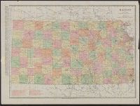
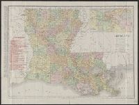
Rand-McNally indexed pocket map and shippers' guide of Kansas
Description:
"Showing all railroads, cities, towns, villages, postoffices, lakes, rivers, etc."--Cover of text., Indexed., Library's copy missing text., Relief shown by hachures., and Shows railroads, military reservations, postal and express services.
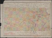
Below scale: Rand McNally & Co.'s new business atlas map of Kansas. Copyright 1911 ... Copyright 1903 ...., Imperfect. Chipped with some loss of text: Ms. annotations to indicate oil fields and drilling., Indexed on verso., Indexed., Relief shown by hachures., and Shows counties and railroads.
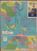
Map of Southern Europe, the Mediterranean area and the Near East., Map of the Far East., War map of Atlantic Ocean area, Eurasia and Africa., War map of Pacific Ocean and the Far East., and War map of the world
Description:
Includes notes, inset of "World time zones," and col. ill., Map of the Far East. Scale [ca. 1:13,000,000] -- Map of Southern Europe, the Mediterranean area and the Near East. Scale [ca. 1:14,500,000] -- Verso: War map of Atlantic Ocean, and On panel title: "B."
Publisher:
Rand McNally & Co.,
Subject (Name):
Thomas, Lowell, 1892-1981
Subject (Topic):
Time--Systems and standards--Maps and World War, 1939-1945--Maps
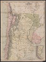
Argentine Republic, Paraguay, Uruguay, & Chile and Rand McNally & Co's indexed Atlas of the World :
Description:
At head of title: Rand McNally & Co's indexed Atlas of the World., Includes 3 inset maps: St. Felix and St. Ambrose islands, Juan Fernandez I., and "Southern portion of Chile and Argentine Republic.", Relief shown by hachures., and Shows railroads completed and railroads projected.