Skip to search
Skip to main content
Skip to first result
Search
You Searched For
Extent of Digitization
Completely digitized
Format
cartographic
Language
English
Publication Place
Chicago :
New Search
Search Results
Creator:
Published / Created:
1916
Call Number:
786 1916
Container / Volume:
BRBL_00515
Image Count:
1
Resource Type:
Maps, Atlases & Globes
Description:
In left margin: Directory of Principal Cities. In lower right corner [Directory of] South Carolina Railroads. and On verso: Directory of Counties, Creeks, Islands, Rivers and Towns.
Publisher:
Rand McNally,
Subject (Geographic):
South Carolina--Maps
Subject (Topic):
Railroads--South Carolina--Maps
Found in:
Beinecke Rare Book and Manuscript Library > The Rand McNally New Commercial Atlas Map of South Carolina.
Creator:
Published / Created:
[1919?]
Call Number:
30 1920D
Container / Volume:
BRBL_00032
Image Count:
1
Resource Type:
Maps, Atlases & Globes
Alternative Title:
New Europe.
Description:
"124E.", Includes text: Summary of the treaty of peace., and Relief shown by hachures.
Publisher:
Rand McNally,
Subject (Geographic):
Europe--Boundaries--Maps
Subject (Topic):
World War, 1914-1918--Territorial questions--Maps
Found in:
Beinecke Rare Book and Manuscript Library > The Rand McNally map of new Europe.
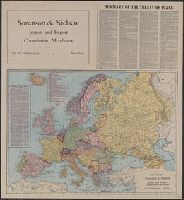
Creator:
Published / Created:
[1917?]
Call Number:
787 1916
Container / Volume:
BRBL_00517
Image Count:
2
Resource Type:
Maps, Atlases & Globes
Alternative Title:
Rand-McNally vest pocket map of Georgia
Description:
Index begins on map verso, continues in accompanying index booklet. and Relief shown by hachures.
Publisher:
Rand McNally & Co.,
Subject (Geographic):
Georgia--Maps
Subject (Topic):
Railroads--Georgia--Maps
Found in:
Beinecke Rare Book and Manuscript Library > The Rand McNally new commercial atlas map of Georgia / Rand McNally & Co.
Creator:
Published / Created:
1914, c1902.
Call Number:
806 1914
Container / Volume:
BRBL_00547
Image Count:
1
Resource Type:
Maps, Atlases & Globes
Alternative Title:
New commercial atlas map of Illinois.
Description:
Includes list of Alabama Railroads, and index., ms. notations in red, green and pencil. Imperfect: pamphlet wanting., and Title of accompanying pamphlet: The Rand-McNally indexed county and township pocket map and shippers' guide of Illinois: showing railroads,
Publisher:
Rand McNally and Co.,
Subject (Geographic):
Illinois--Maps
Subject (Topic):
Railroads--Illinois--Maps
Found in:
Beinecke Rare Book and Manuscript Library > The Rand McNally new commercial atlas map of Illinois [cartographic material].
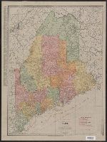
Creator:
Published / Created:
1915
Call Number:
761 1915
Container / Volume:
BRBL_00448
Image Count:
2
Resource Type:
Maps, Atlases & Globes
Description:
Indicates railroads, electric lines and steamship lines., On verso: Index to Maine counties, islands, lakes, ponds, rivers, towns., and Relief shown by hachures.
Publisher:
Rand McNally,
Subject (Geographic):
Maine--Maps
Subject (Topic):
Electric lines--Maine--Maps, Railroads--Maine--Maps, and Steamboat lines--Maine--Maps
Found in:
Beinecke Rare Book and Manuscript Library > The Rand McNally new commercial atlas map of Maine / Rand McNally & Company.
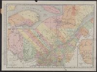
Creator:
Published / Created:
c1920.
Call Number:
734 1920
Container / Volume:
BRBL_00379
Image Count:
1
Resource Type:
Maps, Atlases & Globes
Alternative Title:
New commercial atlas map of Quebec and Quebec
Description:
"239B.", Includes indexes to railroads and principal cities., and Inset: North eastern portion of Quebec -- Western portion of Quebec.
Publisher:
Rand McNally & Co.,
Subject (Geographic):
Québec (Province)--Maps
Subject (Topic):
Railroads--Québec (Province)--Maps and Roads--Québec (Province)--Maps
Found in:
Beinecke Rare Book and Manuscript Library > The Rand McNally new commercial atlas map of Quebec / Rand McNally and Company.
Creator:
Published / Created:
c1912.
Call Number:
823 1912
Container / Volume:
BRBL_00568
Image Count:
1
Resource Type:
Maps, Atlases & Globes
Alternative Title:
New commercial atlas map of South Dakota
Description:
Also shows railroads., Indexed on verso., Indexed., Library's copy annotated in blue pencil., and Relief shown by hachures.
Publisher:
Rand McNally,
Subject (Geographic):
South Dakota--Maps
Subject (Topic):
Railroads--South Dakota--Maps
Found in:
Beinecke Rare Book and Manuscript Library > The Rand McNally new commercial atlas map of South Dakota.
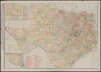
Creator:
Published / Created:
1914
Call Number:
796 1914
Container / Volume:
BRBL_00526
Image Count:
1
Resource Type:
Maps, Atlases & Globes
Alternative Title:
New business atlas map of Texas, New commercial atlas map of Texas, Rand McNally & Co.'s new business atlas map of Texas, and Texas
Description:
Includes insets of the panhandle and southern Texas and indexes., Library's copy annotated in blue pencil and black ink., Relief shown by hachures and spot heights., and Shows counties and railroads.
Publisher:
Rand McNally,
Subject (Geographic):
Texas Panhandle (Tex.)--Maps, Texas--Administrative and political divisions--Maps, and Texas--Maps
Subject (Topic):
Railroads--Texas--Maps
Found in:
Beinecke Rare Book and Manuscript Library > The Rand McNally new commercial atlas map of Texas.
Branch:v1.61.8 ,Deployed:2024-06-20T11:14:46-04:00