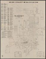
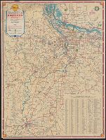
101-mile drive on the rim of the world., Map of principal highways in Southern California., and Map of the city of San Bernardino, California, and the "Rim of the world drive" in the San Bernardino Mountains
Description:
Includes index, statistics, and list of public buildings, schools and parks., Publisher from label on verso covering text of "issued by the San Bernardino Chamber of Commerce.", and Text, "Map of principal highways in Southern California," and "[Map of] The 101-mile drive on the rim of the world" (both maps "courtesy of Automobile Club of Southern California") on verso.
Publisher:
Supplied by Rand McNally & Company,
Subject (Geographic):
San Bernardino (Calif.)--Maps
Subject (Name):
Automobile Club of Southern California, Lowe, A. H, and Rand McNally and Company
Subject (Topic):
Roads--California, Southern--Maps and Streets--California--San Bernardino--Maps
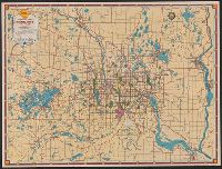
Shell metropolitan Minneapolis, St. Paul and Shell road map, metropolitan Minneapolis, St. Paul
Description:
In lower right: 12-M 1939-1 221-S.C. and Maps of downtown Minneapolis and St. Paul, index, text, and ill. on verso.
Publisher:
H.M. Goushá Co.,
Subject (Geographic):
Minneapolis Metropolitan Area (Minn.)--Maps and Saint Paul Metropolitan Area (Minn.)--Maps
Subject (Name):
Shell Union Oil Corporation
Subject (Topic):
Central business districts--Minnesota--Minneapolis--Maps, Central business districts--Minnesota--Saint Paul--Maps, Roads--Minnesota--Minneapolis Metropolitan Area--Maps, and Roads--Minnesota--Saint Paul Metropolitan Area--Maps
Downtown Spokane., Shell street guide and metropolitan map of Spokane and vicinity, Street guide and metropolitan map of Spokane and vicinity, and Street map of Spokane.
Description:
"469-S" and "10-M 1939-1.", Indexed "Street map of Spokane," "Downtown Spokane" map, text, and ill. on verso., Indexed., and Relief shown by hachures and spot heights.
Publisher:
H.M. Gousha,
Subject (Geographic):
Spokane (Wash.)--Maps and Spokane Metropolitan Area (Wash.)--Maps
Subject (Name):
Shell Union Oil Corporation
Subject (Topic):
Central business districts--Washington (State)--Spokane--Maps, Roads--Washington (State)--Spokane Metropolitan Area--Maps, and Streets--Washington (State)--Spokane--Maps
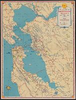
San Francisco and vicinity and Shell metropolitan map, San Francisco and vicinity
Description:
"Copyrighted by the H.M. Goushá Company.", "G-182-S.C.", Index, ill., and "Map of downtown San Francisco, featuring points of interest, parks and principal buildings" on verso., and Relief shown pictorially and by spot heights.
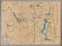
Columbia River highway, Bridal Veil bridge to The Dalles., Downtown Portland., Downtown Salem., Downtown Vancouver., and Shell metropolitan map, Portland and vicinity
Description:
"G-185 S.C.", At head of title: Shell., Ill., and maps of "Downtown Portland," "Downtown Salem," "Downtown Vancouver," and "Columbia River highway: Bridal Veil bridge to The Dalles" (U.S. highway 30) on verso., Indexed., and Relief shown pictorially.
Publisher:
The H.M. Gousha Company,
Subject (Geographic):
Columbia River Gorge (Or. and Wash.)--Maps, Columbia River Highway (Or.)--Maps, Portland (Or.)--Maps, Portland Metropolitan Area (Or.)--Maps, Salem (Or.)--Maps, and Vancouver (Wash.)--Maps
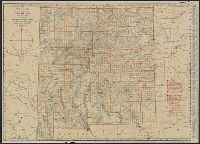
Rand McNally standard map of Montana. and Standard map of Montana with air trails.
Description:
In lower right of air trails map: 12N28, 7R28., Indexed., Relief shown by hachures and spot heights., and Verso: Rand McNally standard map of Montana [without air trails] partially obscured by linen backing.
Rand McNally standard map of New Mexico with air trails., Standard map of New Mexico, and Standard map of New Mexico with air trails.
Description:
"12N28" and "7R28.", Air trails map designed to be used with an "index booklet"; library's copy without booklet., Indexed., Relief shown by hachures and spot heights., and Shows railroads and counties.
Publisher:
Rand McNally & Co.,
Subject (Geographic):
New Mexico--Administrative and political divisions--Maps and New Mexico--Maps
Subject (Topic):
Airways--New Mexico--Maps and Railroads--New Mexico--Maps
Rand McNally standard map of North Dakota. and Standard map of North Dakota with air trails.
Description:
Imperfect : Mounted on linen so standard map on verso [without air trails] is not directly visible., In lower right of air trails map: 12N28, 7R28., Indexed., and Relief shown by hachures and spot heights.