
You Searched For
« Previous
| 1 - 10 of 14 |
Next »
Search Results

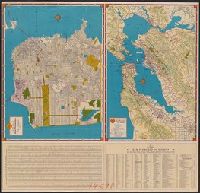
- Creator:
- H.M. Gousha Company
- Published / Created:
- [1940]
- Call Number:
- 844 Sa52 1940
- Container / Volume:
- BRBL_00610
- Image Count:
- 2
- Resource Type:
- Maps, Atlases & Globes
- Alternative Title:
- Metropolitan San Francisco and vicinity., Shell map of San Francisco, Oakland and vicinity, Shell metropolitan San Francisco and vicinity., Shell street map of Bay cities., Shell street map of San Francisco., Street map of Bay cities., and Street map of San Francis
- Description:
- "1940-1", Index and text on verso., Indexed., Panel title., Relief shown by shading, hachures, and spot heights., and Street map of San Francisco -- Metropolitan San Francisco and vicinity -- Street map of Bay cities.
- Publisher:
- H.M. Goushá Co.,
- Subject (Geographic):
- Oakland Metropolitan Area (Calif.)--Maps, San Francisco (Calif.)--Maps, and San Francisco Bay Area (Calif.)--Maps
- Subject (Name):
- Shell Union Oil Corporation
- Subject (Topic):
- Roads--California--Oakland Metropolitan Area--Maps, Roads--California--San Francisco Bay Area--Maps, and Streets--California--San Francisco--Maps
- Found in:
- Beinecke Rare Book and Manuscript Library > Map of San Francisco, Oakland and vicinity / [prepared for] Shell.
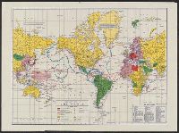
- Creator:
- Rand McNally and Company
- Published / Created:
- [1944?]
- Call Number:
- 11hc 1944C
- Image Count:
- 2
- Resource Type:
- Maps, Atlases & Globes
- Alternative Title:
- Military and naval map of World War II
- Description:
- Ancillary maps on verso: [1.] The far east. Scale [ca. 1:40 900 000] at equator -- [2.] Western hemisphere defense map. Scale [ca. 1:35 000 000]. and Legend and dates of war declarations.
- Publisher:
- Rand McNally and Company,
- Subject (Topic):
- World maps and World War, 1939-1945--Maps
- Found in:
- Beinecke Rare Book and Manuscript Library > Military map of the world.

- Creator:
- Rand McNally and Company
- Published / Created:
- [1944?]
- Call Number:
- 23 1944A
- Container / Volume:
- BRBL_00020
- Image Count:
- 2
- Resource Type:
- Maps, Atlases & Globes
- Alternative Title:
- Rand McNally stratoview map of eastern Asia from the Philippine Sea. and Reference map of the Pacific Ocean with 29 large-scale insets of island groups.
- Description:
- On verso, [ca. 1:13,125,000]: Rand McNally stratoview map of eastern Asia from the Philippine Sea.
- Publisher:
- Rand McNally & Co.,
- Subject (Geographic):
- East Asia--Maps, Islands of the Pacific--Maps, and Pacific Ocean--Maps
- Found in:
- Beinecke Rare Book and Manuscript Library > Rand McNally reference map of the Pacific Ocean with 29 large-scale insets of island groups.

- Creator:
- Rand McNally and Company
- Published / Created:
- [1941]
- Call Number:
- 11hd 1941A-3
- Image Count:
- 2
- Resource Type:
- Maps, Atlases & Globes
- Alternative Title:
- Europe air mileage distances., Far East., Northern Scandinavia., South England and adjacent continental area., World., and World-wide news map :
- Description:
- Inset: Northern Scandinavia. and On verso: South England and adjacent continental area -- The world -- The Far East -- Europe air mileage distances.
- Publisher:
- Rand McNally & Co.,
- Subject (Geographic):
- Europe--Maps
- Subject (Topic):
- World War, 1939-1945--Europe--Maps
- Found in:
- Beinecke Rare Book and Manuscript Library > Richfield news map of Europe [cartographic material].

- Creator:
- Rand McNally and Company
- Published / Created:
- [1943]
- Call Number:
- 11hd 1944T-5
- Container / Volume:
- BRBL_00010ZF
- Image Count:
- 2
- Resource Type:
- Maps, Atlases & Globes
- Alternative Title:
- World. and World-wide news map :
- Description:
- Inset: North Sea and English Channel Area -- Map of the Balkan Area. and On verso: The World -- Rand McNally Polar Map of the World -- Map of Asiatic and Southwest Pacific War Area.
- Publisher:
- Rand McNally & Co.,
- Subject (Geographic):
- Europe--Maps
- Subject (Topic):
- World War, 1939-1945--Europe--Maps
- Found in:
- Beinecke Rare Book and Manuscript Library > Richfield news map of Europe.

- Creator:
- Rand McNally and Company
- Published / Created:
- [1944]
- Call Number:
- 11hd 1944T-6
- Container / Volume:
- BRBL_00010ZF
- Image Count:
- 2
- Resource Type:
- Maps, Atlases & Globes
- Alternative Title:
- World. and World-wide news map :
- Description:
- Inset: North Sea and English Channel Area -- Map of the Balkan Area. and On verso: Rand McNally popular map of the World -- Rand McNally Polar Map of the World -- Map of the Western Pacific.
- Publisher:
- Rand McNally & Co.,
- Subject (Geographic):
- Europe--Maps
- Subject (Topic):
- World War, 1939-1945--Europe--Maps
- Found in:
- Beinecke Rare Book and Manuscript Library > Richfield news map of Europe.

- Creator:
- Rand McNally and Company
- Published / Created:
- [1941]
- Call Number:
- 11hd 1944T-1
- Container / Volume:
- BRBL_00010ZF
- Image Count:
- 2
- Resource Type:
- Maps, Atlases & Globes
- Alternative Title:
- Europe air mileage distances., Far East., Northern Scandinavia., South England and adjacent continental area., World., and World-wide news map
- Description:
- Insets: Northern Scandinavia -- South England and Adjacent Continental Area. and On verso: The World -- Europe Air Mileage Distances -- Map of the Far East -- Map of the Balkans.
- Publisher:
- Rand McNally & Co.,
- Subject (Geographic):
- Europe--Maps
- Subject (Topic):
- World War, 1939-1945--Europe--Maps
- Found in:
- Beinecke Rare Book and Manuscript Library > Richfield news map of Europe.

- Creator:
- Rand McNally and Company
- Published / Created:
- [1942]
- Call Number:
- 11hd 1944T-3
- Container / Volume:
- BRBL_00010ZF
- Image Count:
- 2
- Resource Type:
- Maps, Atlases & Globes
- Alternative Title:
- Far East., Northern Scandinavia., World., and World-wide news map :
- Description:
- Inset: Northern Scandinavia. and On verso: The World -- The Far East -- North Sea and English Channel Area.
- Publisher:
- Rand McNally & Co.,
- Subject (Geographic):
- Europe--Maps
- Subject (Topic):
- World War, 1939-1945--Europe--Maps
- Found in:
- Beinecke Rare Book and Manuscript Library > Richfield news map of Europe.
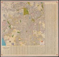
- Creator:
- H.M. Gousha Company
- Published / Created:
- [1940]
- Call Number:
- 844 L89 1940
- Container / Volume:
- BRBL_00606
- Image Count:
- 2
- Resource Type:
- Maps, Atlases & Globes
- Alternative Title:
- Map of Los Angeles and vicinity, Metropolitan Los Angeles and vicinity., Shell street map of Los Angeles., and Street map of Los Angeles.
- Description:
- At head of street map: Shell., In lower right: 10-N-1940-1., Includes indexes, text, ill., and inset of Santa Catalina Island., Panel title., Relief shown by hachures on street map, and by shading and spot heights on metropolitan map., St, and Stamped: Apr 12 1940.
- Publisher:
- H.M. Goushá Co.,
- Subject (Geographic):
- Los Angeles (Calif.)--Maps and Los Angeles Metropolitan Area (Calif.)--Maps
- Subject (Name):
- Shell Oil Company
- Subject (Topic):
- Roads--California--Los Angeles Metropolitan Area--Maps and Streets--California--Los Angeles--Maps
- Found in:
- Beinecke Rare Book and Manuscript Library > Shell map of Los Angeles and vicinity.