Search
You Searched For
Search Results
- Published / Created:
- 1853
- Call Number:
- 806gme G132 1853A
- Container / Volume:
- BRBL_00549
- Image Count:
- 1
- Resource Type:
- Maps, Atlases & Globes
- Found in:
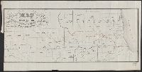
- Beinecke Rare Book and Manuscript Library > Map showing the Galena & Chicago Union Railroad and its connections.
- Creator:
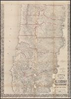
- Trutch, Joseph W. (Joseph William), Sir, 1826-1904
- Published / Created:
- 1856
- Call Number:
- 846 1856
- Image Count:
- 2
- Resource Type:
- Maps, Atlases & Globes
- Found in:
- Beinecke Rare Book and Manuscript Library > Preston's sectional and county map of Oregon and Washington : west of the Cascade mountains / compiled ... by J.W. Trutch and G.W. Hyde.
- Creator:
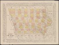
- Morse, Charles W. (Charles Walker), 1823-1887
- Published / Created:
- [1856?]
- Call Number:
- 815 1856D
- Container / Volume:
- BRBL_00560
- Image Count:
- 1
- Resource Type:
- Maps, Atlases & Globes
- Found in:
- Beinecke Rare Book and Manuscript Library > Morse's cerographic map of Iowa.
- Published / Created:
- 1857
- Call Number:
- 806 C43 1857B
- Container / Volume:
- BRBL_00548
- Image Count:
- 1
- Resource Type:
- Maps, Atlases & Globes
- Found in:
- Beinecke Rare Book and Manuscript Library > Map of Chicago.
- Published / Created:
- 1857
- Call Number:
- 806 C43 1857
- Container / Volume:
- BRBL_00548
- Image Count:
- 1
- Resource Type:
- Maps, Atlases & Globes
- Found in:
- Beinecke Rare Book and Manuscript Library > Map of Chicago.
- Published / Created:
- 1860
- Call Number:
- 806gme C43 1860
- Container / Volume:
- BRBL_00549
- Image Count:
- 1
- Resource Type:
- Maps, Atlases & Globes
- Found in:
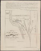
- Beinecke Rare Book and Manuscript Library > Plat exhibiting the location of the Southern Michigan and Rock Island R.R. depots and adjacent grounds. / lithographed by Ed Mendel.
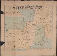
- Creator:
- Wheaton, W. G
- Published / Created:
- [186-]
- Call Number:
- 754gme 1853B
- Container / Volume:
- BRBL_00419
- Image Count:
- 1
- Resource Type:
- Maps, Atlases & Globes
- Found in:
- Beinecke Rare Book and Manuscript Library > Map of the great north west : showing Peoria, Illinois the geographigal [sic] centre / W.G. Wheaton, Civil Engineer Peoria, Ill.
- Creator:
- Colton, G. Woolworth (George Woolworth), 1827-1901
- Published / Created:
- 1862
- Call Number:
- 754gme 1860A
- Container / Volume:
- BRBL_00420
- Image Count:
- 1
- Resource Type:
- Maps, Atlases & Globes
- Found in:
- Beinecke Rare Book and Manuscript Library > Colton's county and township rail road map of Wisconsin, Illinois, Missouri, & Iowa / Drawn, engraved & published by G. Woolworth Colton
- Creator:
- Colton, G. Woolworth (George Woolworth), 1827-1901
- Published / Created:
- 1862, c1861.
- Call Number:
- 75 1862C
- Container / Volume:
- BRBL_00403
- Image Count:
- 1
- Resource Type:
- Maps, Atlases & Globes
- Found in:
- Beinecke Rare Book and Manuscript Library > G. Woolworth Colton's new guide map of the United States & Canada : with railroads, counties etc. / drawn, engraved & published by G. Woolworth Colton.
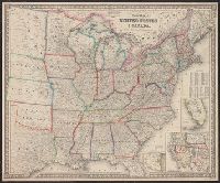
- Creator:
- Case, Francis M
- Published / Created:
- 1868
- Call Number:
- 834gme 1868
- Container / Volume:
- BRBL_00591
- Image Count:
- 1
- Resource Type:
- Maps, Atlases & Globes
- Found in:
- Beinecke Rare Book and Manuscript Library > Denver Pacific Railway map showing the final location with prospective connections : compiled from railroad and gov't. surveys / F.M. Case.