
You Searched For
1 entry found
Search Results
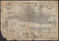
1. Londinum feracissimi Angliae Regni metropolis
- Creator:
- Hogenberg, Frans, approximately 1539-1590, engraver
- Published / Created:
- [1574]
- Call Number:
- 32 L84 1572
- Image Count:
- 2
- Resource Type:
- cartographic image
- Description:
- BEIN 32 L84 1572: Manuscript annotations on verso in pencil and ink offering and justifying potential dates of 1561 and 1572., Second edition of the earliest surviving printed map of London (first published in 1572). It is likely that the plan is a derivitive, reduced in size, of the Copperplate Map of ca. 1556-1558, which survives only in 3 of 20 original engraved copper plates., Relief shown pictorially., From Braun and Hogenburg's Civitates orbis terrarum, 1574., "Assumed to have been engraved by Frans Hogenberg, to whom it is attributed by Hind ... Although ... [the first edition] was published in 1572 the London map was clearly based on information gathered some years earlier. St Paul's is shown with its spire which was destroyed in 1561. The cross in St. Botolph's Churchyard, burnt in 1559, is also shown. ..."--Howgego., "The image represents a true plan, but it has been disguised by the three-dimensional rendering of the buildings and the boats on the Thames and by the notion that it is a panoramic view from the hill that the four figures in the foreground parade on. The idea of the plan was clearly familiar to the original surveyors but it was not one that was acceptable to a popular audience."--Foxell., "Title, etc., as for [the first edition] but some alterations on the plate. For example 'Westmester' had been changed to 'Westmuster' and the Royal Exchange has been inserted. In the 1574 and later edits of the Civitates."--Howgego., Latin notes on London and the Steelyard in panels bottom left and right corners; descriptive Latin text printed on the verso., Tudor and city of London coats of arms top left and top right of plate; four figures in contemporary costumes bottom centre., Coordinates not present on map and are approximated., and BAC: British Art Center copy is hand-colored.
- Publisher:
- Braun and Hogenberg
- Subject (Geographic):
- London (England)
- Subject (Topic):
- Maps and Early works to 1800
- Found in:
- Beinecke Rare Book and Manuscript Library > Londinum feracissimi Angliae Regni metropolis