Search
You Searched For
Search Results
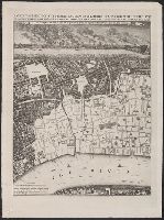
- Creator:
- Rocque, John, -1762
- Published / Created:
- 1746. and 1913-1919.
- Call Number:
- 32 L84 1746/1919
- Container / Volume:
- BRBL_00738
- Image Count:
- 49
- Resource Type:
- Maps, Atlases & Globes
- Found in:
- Beinecke Rare Book and Manuscript Library > A plan of the cities of London and Westminster, and borough of Southwark, with the contiguous buildings; from an actual survey, taken by John Rocque and engraved by John Pine.
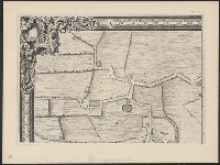
- Creator:
- Moore, Jonas, Sir, 1617-1679
- Published / Created:
- 1662?] and 1912.
- Call Number:
- 32 L84 1662/1912
- Container / Volume:
- BRBL_00737
- Image Count:
- 1
- Resource Type:
- Maps, Atlases & Globes
- Found in:
- Beinecke Rare Book and Manuscript Library > A prospect and map of London, showing the River Thames to Woolwich reach. Drawn by Jonas Moore in 1662.
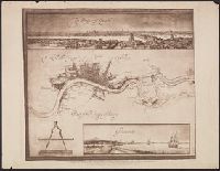
- Creator:
- Newcourt, Richard, d. 1679
- Published / Created:
- 1658. and 1905.
- Call Number:
- 32 L84 1658/1905
- Container / Volume:
- BRBL_00737
- Image Count:
- 12
- Resource Type:
- Maps, Atlases & Globes
- Found in:
- Beinecke Rare Book and Manuscript Library > An exact delineation of the cities of London and Westminster and the suburbs thereof, together wth. ye burrough of Sovthwark and all ye through-fares, highwaies, streetes, lanes & common allies wthin. ye same. Composed by a scale, and ichnographically described by Richard Newcovrt of Somerton in the countie of Somersett, gentleman. Willm. Faithorne, sculpsit.
- Creator:
- Leake, John
- Published / Created:
- [1669?] and 1908-1909.
- Call Number:
- 32 L84 1667/1908
- Container / Volume:
- BRBL_00737
- Image Count:
- 2
- Resource Type:
- Maps, Atlases & Globes
- Found in:
- Beinecke Rare Book and Manuscript Library > An exact svrveigh of the streets, lanes, and chvrches contained within the rvines of the city of London; first described in six plats by Iohn Leake, Iohn Iennings, William Marr, Willm. Leybovrn, Thomas Streete, & Richard Shortgrave in Decber. ao. 1666; by the order of the Lord Mayor, aldermen, and common covncell of the said city; reduced here into one intire plat by Iohn Leake ... Wenceslaus Hollar, fecit, 1667.
- Creator:
- Morgan, William, -1690
- Published / Created:
- 1682] and 1904.
- Call Number:
- 32 L84 1682/1904
- Container / Volume:
- BRBL_00737
- Image Count:
- 12
- Resource Type:
- Maps, Atlases & Globes
- Found in:
- Beinecke Rare Book and Manuscript Library > London &c. actually surveyed, by Wm. Morgan, his ma[jes]ties cosmogr., 1681/2.
- Creator:
- Hollar, Wenceslaus, 1607-1677
- Published / Created:
- 1647. and 1906-1907.
- Call Number:
- 32 L84 1647/1906
- Container / Volume:
- BRBL_00737
- Image Count:
- 6
- Resource Type:
- Maps, Atlases & Globes
- Found in:
- Beinecke Rare Book and Manuscript Library > London. Wenceslaus Hollar delineavit et fecit Londini et Antverpiæ, 1647.
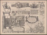
- Creator:
- Great Britain. Commissioners of Works
- Published / Created:
- 1900
- Call Number:
- 32 L84 1680/1896
- Container / Volume:
- BRBL_00736
- Image Count:
- 1
- Resource Type:
- Maps, Atlases & Globes
- Found in:
- Beinecke Rare Book and Manuscript Library > Plan of buildings in the neighbourhood of Whitehall, showing thereon in red colour the Cockpit and ancient buildings in the neighbourhood thereof, as they stood in 1680. [By] H. M. Office of Works, 1897.