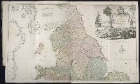
Kitchin, Thomas, d. 1784, creator Sayer, Robert, 1725-1794, publisher
Published / Created:
1787 January 1
Call Number:
1982 Folio 10
Image Count:
2
Alternative Title:
England & Wales and South Britain
Description:
Imperfect: both sheets torn along some folds, with some loss of text., Inset map: Isles of Scilly., London meridian., No. 5 of 43 maps bound together in composite atlas., Relief shown pictorially and by hill shading., and Scale [ca. 1:575,000].
Publisher:
R. Sayer
Subject (Geographic):
England --Maps --Early works to 1800 and Wales --Maps --Early works to 1800
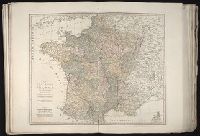
Also appeared in Kitchin's General atlas describing the whole universe. London : Printed Robert Sayer and J. Bennet, 1773; and General atlas describing the whole universe. London : Printed and sold for R. Sayer and J. Bennet, 1780., Ferro meridian., Ms. notes on, and newspaper clipping pasted to, verso. No. 14 of 43 maps bound together in composite atlas., Relief shown pictorially., Scale [1:2,300,000]., and Shows boundaries, rivers and settlements.
Publisher:
Printed for Rob. Sayer
Subject (Geographic):
Iberian Peninsula, Portugal --Maps --Early works to 1800, and Spain --Maps --Early works to 1800
Also appeared in Kitchin's General atlas describing the whole universe. London : Printed Robert Sayer and J. Bennet, 1773; and General atlas describing the whole universe. London : Printed and sold for R. Sayer and J. Bennet, 1780., Ferro meridian., France divided into regions., From the map of Jaillot., No. 12 of 43 maps bound together in composite atlas., Relief shown pictorially., Scale [1:2,250,000]., and Shows boundaries, rivers, roads with distances and settlements.