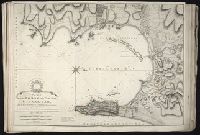
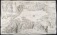
Also appeared in Faden's [General atlas. London : William Faden, 1811?]., In cartouche above title: The Roman obsidional crown, Parcere subjectis et debellare superbos., No. 15 of 43 maps bound together in composite atlas., Oriented with north toward right., Relief shown by hachures; depths by soundings., Scale [ca. 1:24,700]., and Shows ocean currents, buildings, forts, fields, magnetic declination, etc.
Publisher:
William Faden
Subject (Geographic):
Gibraltar --History --Siege, 1779-1783 --Maps --Early works to 1800, Gibraltar --Maps --Early works to 1800, and Gibraltar, Bay of (Spain) --Maps --Early works to 1800
Kitchin, Thomas, d. 1784, creator Sayer, Robert, 1725-1794, publisher
Published / Created:
1787 January 1
Call Number:
1982 Folio 10
Image Count:
2
Alternative Title:
England & Wales and South Britain
Description:
Imperfect: both sheets torn along some folds, with some loss of text., Inset map: Isles of Scilly., London meridian., No. 5 of 43 maps bound together in composite atlas., Relief shown pictorially and by hill shading., and Scale [ca. 1:575,000].
Publisher:
R. Sayer
Subject (Geographic):
England --Maps --Early works to 1800 and Wales --Maps --Early works to 1800
Delarochette, L. (Louis), 1731-1802, creator Faden, William, 1749-1836
Published / Created:
1782 March 20
Call Number:
1982 Folio 10
Image Count:
1
Description:
No. 37 of 43 maps bound together in composite atlas., Place names in Dutch; pictorial relief. "The red line describes the route of the British Army from its landing at Simons Baay to Cape Town.", and Scale [ca. 1:528 000].
Publisher:
W. Faden
Subject (Geographic):
Cape of Good Hope (South Africa) --Maps --Early works to 1800
Imperatorskaia akademia nauk (Russia) Kitchin, Thomas, d. 1784, creator Sayer, Robert, 1725-1794
Published / Created:
1788 May 1
Call Number:
1982 Folio 10
Image Count:
2
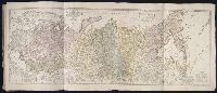
Alternative Title:
Asiatic part of the Russian empire : from the maps published by the Imperial Academy of St. Petersburg with the new discoveries of Captn. Cook &c
Description:
Also appeared in Kitchin's General atlas describing the whole universe. London : Printed R. Sayer and J. Bennet, 1780., No. 25 of 43 maps bound together in composite atlas., Prime meridian: Ferro., Relief shown pictorially., Scale [ca. 1:8,000,000]., Sheets mounted together to form 1 sheet., and Shows vegetation, sailing and explorers tracks, etc.
Also appeared in Kitchin's General atlas describing the whole universe. London : Printed Robert Sayer and J. Bennet, 1773; and General atlas describing the whole universe. London : Printed and sold for R. Sayer and J. Bennet, 1780., Ferro meridian., Ms. notes on, and newspaper clipping pasted to, verso. No. 14 of 43 maps bound together in composite atlas., Relief shown pictorially., Scale [1:2,300,000]., and Shows boundaries, rivers and settlements.
Publisher:
Printed for Rob. Sayer
Subject (Geographic):
Iberian Peninsula, Portugal --Maps --Early works to 1800, and Spain --Maps --Early works to 1800
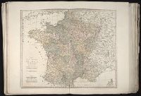
Also appeared in Kitchin's General atlas describing the whole universe. London : Printed Robert Sayer and J. Bennet, 1773; and General atlas describing the whole universe. London : Printed and sold for R. Sayer and J. Bennet, 1780., Ferro meridian., France divided into regions., From the map of Jaillot., No. 12 of 43 maps bound together in composite atlas., Relief shown pictorially., Scale [1:2,250,000]., and Shows boundaries, rivers, roads with distances and settlements.
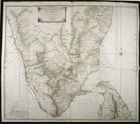
Map with relief shown pictorially, by hachures, and bathymetric soundings., No. 32 of 43 maps bound together in composite atlas., and Scale [ca. 1: 720 000].
Publisher:
Printed for Wm. Faden
Subject (Geographic):
India, South --History, Military --Maps --Early works to 1800
Anville, Jean Baptiste Bourguignon d', 1697-1782 Compagnie des Indes Jefferys, Thomas, d. 1771, creator Kitchin, Thomas, d. 1784 Robert Laurie and James Whittle Sayer, Robert, 1725-1794
Published / Created:
1789 January 1
Call Number:
1982 Folio 10
Image Count:
1
Description:
Also appeared in Kitchin's General atlas describing the whole universe. London : Printed for Robert Sayer, [1780]., Has illustrated cartouche and includes text., No. 36 of 43 maps bound together in composite atlas., Norwich, O.I. Norwich's maps of Africa., Prime meridians: Ferro and London., Relief shown pictorially; depths by soundings., Scale [ca. 1:1,850,000]., and This map is copied from an original drawn by Monsr. D'Anville at the expense of the French East India Company, & published at Paris. The country thorough [sic] which the R. Senegal runs has been improved & corrected from a large & curious survey of that river found in the Fort of Senegal.
Publisher:
Printed for by Robert Sayer
Subject (Geographic):
Africa, West --Maps --Early works to 1800
Subject (Topic):
Coasts --Africa, West --Maps --Early works to 1800