Chart of the northwest coast of America and the northeast coast of Asia, explored in the years 1778 and 1779
Description:
Includes notes., No. 34 of 43 maps bound together in composite atlas., Prepared by Lieut. Heny. Roberts, under the immediate inspection of Capt. Cook ; engraved by W. Palmer., Relief shown pictorially. Depths shown by soundings., and Scale [ca. 1:13,500,000].
Publisher:
Wm. Faden, geographer to the King, Charing Cross
Subject (Geographic):
Bering Strait Region --Discovery and exploration --Maps --Early works to 1800, North America --Discovery and exploration --Maps --Early works to 1800, Pacific Coast (North America) --Discovery and exploration --Maps --Early works to 1800, and Russian Far east (Russia) --Discovery and exploration --Maps --Early works to 1800
Subject (Name):
Cook, James, 1728-1779
Subject (Topic):
Discoveries in geography --Maps --Early works to 1800
Kitchin, Thomas, d. 1784, creator Sayer, Robert, 1725-1794
Published / Created:
1787 January 1
Call Number:
1982 Folio 10
Image Count:
2
Description:
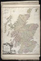
Also appeared in Kitchin's General atlas, describing the whole universe. London : Printed and sold for R. Sayer and J. Bennet, 1780., By Thos. Kitchin, hydrographer to the king ; with many additions and improvements from the latest surveys and observations., No. 4 of 43 maps bound together in composite atlas., Pictorial relief., Scale [ca. 1:4,800,000]., and Western part of the northern states including the British Islands, Norway, Denmark and part of Sweden -- Eastern part of the northern states, including the eastern part of Sweden; European Russia, &c. -- Western part of the Mediterranean Sea with the coasts of Spain, France, Italy, Barbary -- Eastern part of the Mediterranean Sea with the coasts of Turky [sic], Anatolia, Syria, Egypt and Barbary.
Publisher:
Robert Sayer
Subject (Geographic):
Africa, North --Maps --Early works to 1800, Europe --Maps --Early works to 1800, and Middle east --Maps --Early works to 1800
Delarochette, L. (Louis), 1731-1802, creator Faden, William, 1749-1836 Meta, C. Palmer, W. (William), 1739-1812
Published / Created:
1790 January 1
Call Number:
1982 Folio 10
Image Count:
1
Description:
Also appeared in Faden's [General atlas. London : William Faden, 1811?]., Includes illustrated cartouche C. Meta fec., No. 28 of 43 maps bound together in composite atlas., Relief shown pictorially., and Scale [ca. 1:1,350,000].
Publisher:
Willm. Faden
Subject (Geographic):
Greece --Maps --Early works to 1800 and Turkey --Maps --Early works to 1800
Eastern old world hemisphere has imprint: London ... Dec. 1st, 1786 by William Faden., No. 2 of 43 maps bound together in composite atlas., Scale [1:60,000,000]., and Shows western and eastern hemispheres separately.
Ed. statement appears on Northern Hemisphere map only., No. 3 of 43 maps bound together in composite atlas., Relief shown pictorially., Scale [ca. 1:41,000,000. At equator]., and Shows tracks of various ocean voyages.
Publisher:
William Faden
Subject (Geographic):
Northern Hemisphere --Maps --Early works to 1800 and Southern Hemisphere --Maps --Early works to 1800
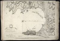
Also appeared in Faden's [General atlas. London : William Faden, 1811?]., In cartouche above title: The Roman obsidional crown, Parcere subjectis et debellare superbos., No. 15 of 43 maps bound together in composite atlas., Oriented with north toward right., Relief shown by hachures; depths by soundings., Scale [ca. 1:24,700]., and Shows ocean currents, buildings, forts, fields, magnetic declination, etc.
Publisher:
William Faden
Subject (Geographic):
Gibraltar --History --Siege, 1779-1783 --Maps --Early works to 1800, Gibraltar --Maps --Early works to 1800, and Gibraltar, Bay of (Spain) --Maps --Early works to 1800
Kitchin, Thomas, d. 1784, creator Sayer, Robert, 1725-1794, publisher
Published / Created:
1787 January 1
Call Number:
1982 Folio 10
Image Count:
2
Alternative Title:
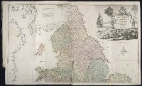
England & Wales and South Britain
Description:
Imperfect: both sheets torn along some folds, with some loss of text., Inset map: Isles of Scilly., London meridian., No. 5 of 43 maps bound together in composite atlas., Relief shown pictorially and by hill shading., and Scale [ca. 1:575,000].
Publisher:
R. Sayer
Subject (Geographic):
England --Maps --Early works to 1800 and Wales --Maps --Early works to 1800