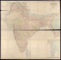
1. Map of India : shewing the British territories, subdivided into collectorates and including British Creator: Walker, John, 1786-1873, cartographer Published / Created: 1882. Call Number: Covers 59 +1882 Image Count: 2 Resource Type: cartographic image Found in: Beinecke Rare Book and Manuscript Library > Map of India : shewing the British territories, subdivided into collectorates and including British Burmah, with the position and boundary of each native state
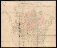
2. A map exhibiting all the new discoveries in the interior parts of North America : inscribed by Creator: Arrowsmith, Aaron, 1750-1823, cartographer Published / Created: [1820] Call Number: 71 1820B Image Count: 1 Resource Type: cartographic image Found in: Beinecke Rare Book and Manuscript Library > A map exhibiting all the new discoveries in the interior parts of North America : inscribed by permission to the honorable governor and company of adventurers of England trading into Hudsons Bay, in testimony of their liberal communications to their most obedient and very humble servant, A. Arrowsmith, Hydrographer to His Majesty