Search
You Searched For
Search Results
- Creator:
- Lowe, George, fl. 1613?-ca. 1615?, printer
Pass, Simon van de, 1595?-1647, engraver.
- Published / Created:
- 1624
- Call Number:
- 2003 +39
- Collection Title:
- The generall historie of Virginia, New-England, and the Summer Iles ...
- Image Count:
- 1
- Subject (Geographic):
- New England--Maps--Early works to 1800
- Subject (Topic):
- New England--History--Colonial period
- Found in:
- Beinecke Rare Book and Manuscript Library > New England
- Creator:
- Blaskowitz, Charles
- Published / Created:
- 1777.
- Call Number:
- Drawer 777.07.22.01+
- Image Count:
- 1
- Found in:
- Lewis Walpole Library > A topographical chart of the bay of Narraganset in the province of New England : with all the isles contained therein, among which Rhode Island and Connonicut have been particularly surveyed, shewing the true position & bearings of the banks, shoals, rocks &c. as likewise the soundings: To which have been added the several works & batteries raised by the Americans. Taken by order of the principal farmers on Rhode Island
- Creator:
- Vaughan, Robert, 17th cent., engraver
- Published / Created:
- 1624
- Call Number:
- 2003 +39
- Collection Title:
- The generall historie of Virginia, New-England, and the Summer Iles ...
- Image Count:
- 1
- Subject (Topic):
- New England --History --Colonial period
- Found in:
- Beinecke Rare Book and Manuscript Library > A description of part of the adventures of Cap. Smith in Virginia
- Creator:
- Russell, John, fl. 1733-1795
- Published / Created:
- 1795 February 7
- Call Number:
- 1986 102
- Collection Title:
- An historical, geographical, commercial, and philosophical view of the American United States, and
- Image Count:
- 1
- Subject (Geographic):
- New England --Maps --Early works to
- Found in:
- Beinecke Rare Book and Manuscript Library > Map of the northern, or, New England states of America. Comprehending Vermont, New Hampshire, District of Main, Massachusetts, Rhode-Island, and Connecticut
- Creator:
- Jefferys, Thomas, d. 1771, creator
- Published / Created:
- 1755
- Call Number:
- 2003 Folio 85
- Image Count:
- 1
- Description:
- Shows Maritime Provinces, New England
- Subject (Geographic):
- New England -- Maps -- Early works to
- Found in:
- Beinecke Rare Book and Manuscript Library > A new map of Nova Scotia, and Cape Britain: With the adjacent parts of New England and Canada, composed from a great number of actual surveys; and other materials regulated by many new astronomical observations of the longitude as well as latitude; with a
- Creator:
- Godbid, Anne, printer.
Playford, John, ca. 1655-1685 or 6, printer.
Seller, John, fl. 1658-1698, bookseller
Seller, John, fl. 1658-1698.
- Published / Created:
- 1682
- Call Number:
- Taylor 384
- Image Count:
- 50
- Found in:
- Beinecke Rare Book and Manuscript Library > Atlas maritimus, or, A sea-atlas : describing the sea-coasts in most of the known parts of the world / by John Seller, hydrographer to the King
- Creator:
- Vaughan, Robert, 17th cent., engraver
- Published / Created:
- 1624
- Call Number:
- Pequot +Sm4
- Collection Title:
- The generall historie of Virginia, New-England, and the Summer Isles : with the names of the
- Image Count:
- 1
- Subject (Topic):
- New England --History --Colonial period
- Found in:
- Beinecke Rare Book and Manuscript Library > A description of part of the adventures of Cap. Smith in Virginia
- Creator:
- Jefferys, Thomas, d. 1771, creator
Mellon, Paul
- Published / Created:
- November 29th 1755
- Call Number:
- 2003 Folio 85
- Image Count:
- 1
- Subject (Geographic):
- New England -- Maps -- Early works to
- Found in:
- Beinecke Rare Book and Manuscript Library > A map of the most inhabited part of New England: containing the provinces of Massachusets Bay and New Hampshire, with the colonies of Conecticut and Rhode Island : divided into counties and townships : the whole composed from actual surveys and its situat
- Published / Created:
- 1776
- Call Number:
- Cb23 27
- Collection Title:
- The American military pocket atlas : being an approved collection of correct maps, both general and
- Image Count:
- 1
- Alternative Title:
- , Newfoundland, Nova-Scotia, New-England, New-York
- Subject (Geographic):
- New England --Maps --Early works to
- Found in:
- Beinecke Rare Book and Manuscript Library > A General map of the northern British colonies in America. which comprehends the province of Quebec, the government of Newfoundland, Nova-Scotia, New-England and New-York. From the maps published by the Admiralty and Board of Trade regulated by the astronomic and trigonometric observations of M. von Holland and corrected from Governor Pownall's late map 1776.
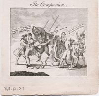
- Published / Created:
- [1768]
- Call Number:
- 768.12.00.02
- Image Count:
- 1
- Resource Type:
- still image
- Description:
- colonies: New England -- Reference to the
- Found in:
- Lewis Walpole Library > The colonies reduced Its companion / [graphic]