Skip to search
Skip to main content
Skip to first result
Search
You Searched For
"United States--Maps"
Repository
Beinecke Rare Book and Manuscript Library
Resource Type
Maps, Atlases & Globes
Language
English
Creator
Wyld, James, 1812-1887
Publication Place
London :
New Search
Search Results
Creator:
Published / Created:
[1870?]
Call Number:
75 1870B
Container / Volume:
BRBL_00404
Image Count:
1
Resource Type:
Maps, Atlases & Globes
Alternative Title:
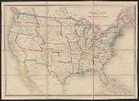
United States and the relative position of the Oregon and Texas
Description:
In lower right margin: 37., Inset: England, Wales & Scotland -- same scale., and Map of the United States. Relief shown by hachures.
Publisher:
Published by Jas. Wyld, Geographer to the Queen & H.R.H. Prince Albert, Charing Cross East,
Subject (Geographic):
United States --Maps
Found in:
Beinecke Rare Book and Manuscript Library > The United States & the relative position of the Oregon & Texas / by James Wyld, Charing Cross East.
Creator:
Published / Created:
[1857]
Call Number:
75 1857A
Container / Volume:
BRBL_00401
Image Count:
1
Resource Type:
Maps, Atlases & Globes
Alternative Title:
United States and the relative position of the Oregon and Texas
Description:
Inset: Great Britain, on the same scale. and Map of the United States. Relief shown by hachures.
Publisher:
Jas. Wyld,
Subject (Geographic):
United States --Maps
Found in:
Beinecke Rare Book and Manuscript Library > The United States & the relative position of the Oregon & Texas / by James Wyld, Charing Cross East.
Creator:
Published / Created:
July 16th, 1858.
Call Number:
739 1858
Container / Volume:
BRBL_00388
Image Count:
2
Resource Type:
Maps, Atlases & Globes
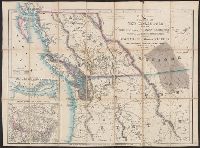
Description:
Cut and mounted on linen; "Wyld's new maps" advertisement on verso., Forts; boundaries; Indians; proposed railway; gold; coal., and Insets: Strait of San Juan de Fuca. -- on an enlarged scale. -- 7.4 x 8 cm.; British possessions in North America. -- scale [1:34
Publisher:
James Wyld,
Subject (Geographic):
Canada--Boundaries--United States --Maps
Subject (Topic):
Coal mines and mining--North America, Western--Maps, Gold mines and mining--British Columbia--Maps, and Indians--North America, Western--Maps
Found in:
Beinecke Rare Book and Manuscript Library > Map of the colony of New Caledonia and the British & American territory west of the Rocky mountains including Vancouvers Island and the gold fields [cartographic material] / by James Wyld, geographer to the Queen & the Prince Consort, Charing Cross East,
Branch:v1.61.6 ,Deployed:2024-06-12T09:55:37-04:00