Skip to search
Skip to main content
Skip to first result
Search
You Searched For
Extent of Digitization
Completely digitized
Access
Public
Repository
Beinecke Rare Book and Manuscript Library
Format
cartographic
Publication Place
London :
New Search
Search Results
Creator:
Published / Created:
1873
Call Number:
6555 1873
Container / Volume:
BRBL_00346
Image Count:
1
Resource Type:
Maps, Atlases & Globes
Description:
At head of sheet: "Wylds Military Map". and Insets: Enlarged map [of the route from Coomassie to Anamaboe and Cape Coast Castle; Location maps of Africa and West Africa].
Publisher:
James Wyld,
Subject (Geographic):
Ashanti Region (Ghana)--Maps
Found in:
Beinecke Rare Book and Manuscript Library > Wyld's Map of Ashanti : and neighbouring states with the British Possessions on the Gold Coast / published by James Wyld, Geographer to the Queen, 457 Strand, 11 & 12 Charing Cross & 2 Royal Exchange, London, November 20, 1873.
Creator:
Published / Created:
[1875?]
Call Number:
60 1875
Container / Volume:
BRBL_00327
Image Count:
1
Resource Type:
Maps, Atlases & Globes
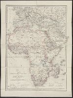
Alternative Title:
Africa, Map shewing the various explorations in Africa, and Wyld's map showing the various explorations in Africa
Description:
Relief shown by hachures.
Publisher:
J. Wyld,
Subject (Geographic):
Africa--Discovery and exploration--Maps
Found in:
Beinecke Rare Book and Manuscript Library > Wyld's map shewing the various explorations in Africa / James Wyld.
Creator:
Published / Created:
1861
Call Number:
754hc 1861E
Container / Volume:
BRBL_00420
Image Count:
1
Resource Type:
Maps, Atlases & Globes
Description:
Insets: City of Washington and District of Columbia. Scale ca. 1:190,000. 13 x 14 cm. Country round Washington. Scale ca. 1:1,020,000. 18 x 24 cm.-Pensacola bay and its fortifications. Scale ca. 1:155,000. 12 x 14 cm.-Charleston and the harbour. Scale ca.
Publisher:
James Wyld
Subject (Geographic):
United States--History--Civil War, 1861-1865--Maps
Found in:
Beinecke Rare Book and Manuscript Library > Wyld's military map of the United States, the northern states, and the southern confederate states: with the forts, harbours, arsenals, and military positions.
Creator:
Published / Created:
[1862]
Call Number:
32 L84 1862
Container / Volume:
BRBL_00050
Image Count:
1
Resource Type:
Maps, Atlases & Globes
Alternative Title:
Neuer Plan von London and Nouveau plan de Londres
Description:
Border includes engravings of prominent structures., Imperfect: mutilated with loss of text., and Map in English; some data also in French and German.
Publisher:
Published by James Wyld, Geographer to the Queen and H.R.H. Prince Albert,
Subject (Geographic):
London (England)--Maps
Found in:
Beinecke Rare Book and Manuscript Library > Wyld's new plan of London = Nouveau plan des Londres = Neuer Plan von London.
Branch:v1.61.6 ,Deployed:2024-06-12T09:55:37-04:00