Skip to search
Skip to main content
Skip to first result
Search
You Searched For
"Austria--Maps"
Extent of Digitization
Completely digitized
Repository
Beinecke Rare Book and Manuscript Library
Genre
Maps
Publication Place
London :
New Search
Search Results
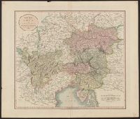
Published / Created:
1811
Call Number:
41 AU79 1811
Container / Volume:
BRBL_00242
Image Count:
1
Resource Type:
Maps, Atlases & Globes
Publisher:
J. Cary,
Subject (Geographic):
Austria --Maps
Found in:
Beinecke Rare Book and Manuscript Library > A new map of the circle of Austria ... / by John Cary, engraver.
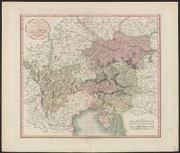
Published / Created:
1801
Call Number:
41 AU79 1801
Container / Volume:
BRBL_00242
Image Count:
1
Resource Type:
Maps, Atlases & Globes
Publisher:
J. Cary,
Subject (Geographic):
Austria --Maps
Found in:
Beinecke Rare Book and Manuscript Library > A new map of the circle of Austria ... / by John Cary, engraver.
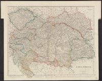
Published / Created:
1832
Call Number:
41 1832
Container / Volume:
BRBL_00241
Image Count:
1
Resource Type:
Maps, Atlases & Globes
Publisher:
J. Arrowsmith,
Subject (Geographic):
Austria --Maps
Found in:
Beinecke Rare Book and Manuscript Library > Austrian Empire / by J. Arrowsmith.
Creator:
Published / Created:
[1917]
Call Number:
11hc 1919Y
Image Count:
2
Resource Type:
Maps, Atlases & Globes
Description:
Area: from Baltic Sea to Innsbruck ; from Luxemburg to Warsaw., Imperfect. Cover wanting, some text lost., Includes index., and Shows: camps and hospitals for British prisoners, towns, rivers and roads.
Publisher:
Nisbet & Co.,
Subject (Geographic):
Austria --Maps
Subject (Topic):
World War, 1914-1918--Maps and World War, 1914-1918--Prisoners and prisons, German--Maps
Found in:
Beinecke Rare Book and Manuscript Library > Map of the main prison camps in Germany and Austria / by Mrs Pope-Hennessy.
Creator:
Published / Created:
1915
Call Number:
11hcf 1919E-5
Container / Volume:
BRBL_00010ZA
Image Count:
1
Resource Type:
Maps, Atlases & Globes
Alternative Title:
Europe 1:1,000,000, G.S.G.S. ; no. 2758, and G.S.G.S. ; no. 2758.
Description:
Copy 2 ms. notes, hand col. spots on map. and Includes index to adjoining sheets, index to boundaries, and pronunciation glossary.
Publisher:
Ordnance Survey,
Subject (Geographic):
Austria --Maps
Found in:
Beinecke Rare Book and Manuscript Library > (Vienna) Wien : North M 33. / compiled at the Royal Geographical Society under the direction of the Geographical Section ; drawn and printed by Ordnance Survey.
Creator:
Published / Created:
1918
Call Number:
11hcf 1919E-6
Container / Volume:
BRBL_00010ZA
Image Count:
1
Resource Type:
Maps, Atlases & Globes
Alternative Title:
Europe 1:1,000,000, G.S.G.S. ; no. 2758, and G.S.G.S. ; no. 2758.
Description:
"Minor corrections December 1918." and Includes index to adjoining sheets, index to boundaries, and pronunciation glossary.
Publisher:
Ordnance Survey,
Subject (Geographic):
Austria --Maps
Found in:
Beinecke Rare Book and Manuscript Library > (Vienna) Wien : North M 33. / compiled at the Royal Geographical Society under the direction of the Geographical Section ; drawn and printed by Ordnance Survey.
Creator:
Published / Created:
1915
Call Number:
11hcf 1919E-5
Container / Volume:
BRBL_00010ZA
Image Count:
1
Resource Type:
Maps, Atlases & Globes
Alternative Title:
Europe 1:1,000,000, G.S.G.S. ; no. 2758, and G.S.G.S. ; no. 2758.
Description:
Includes index to adjoining sheets, index to boundaries, and pronunciation glossary.
Publisher:
Ordnance Survey,
Subject (Geographic):
Austria --Maps
Found in:
Beinecke Rare Book and Manuscript Library > (Vienna) Wien : North M 33. / compiled at the Royal Geographical Society under the direction of the Geographical Section ; drawn and printed by Ordnance Survey.
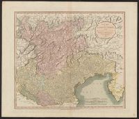
Published / Created:
1811
Call Number:
40 1811
Container / Volume:
BRBL_00199
Image Count:
1
Resource Type:
Maps, Atlases & Globes
Publisher:
Publish'd by J. Cary ... ,
Subject (Geographic):
Tyrol (Austria )--Maps
Found in:
Beinecke Rare Book and Manuscript Library > A new map of the county of Tyrol, and the republic of Venice ... / by John Cary, engraver.
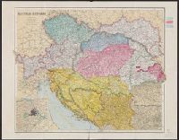
Published / Created:
[1912]
Call Number:
41 1912
Container / Volume:
BRBL_00241
Image Count:
1
Resource Type:
Maps, Atlases & Globes
Description:
Inset: Environs of Vienna.
Publisher:
George Philip & Son, Ltd.,
Subject (Geographic):
Austria --Maps
Found in:
Beinecke Rare Book and Manuscript Library > Austria-Hungary / The London Geographical Institute.
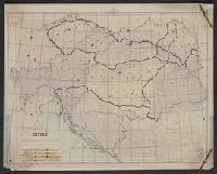
Creator:
Published / Created:
[191-?]
Call Number:
11hcf 1919A-18
Container / Volume:
BRBL_00010M
Image Count:
2
Resource Type:
Maps, Atlases & Globes
Description:
Includes col. overlay labeled "Cities" showing populations. "No. 6" outside upper right margin of overlay., Includes inset of Vienna and environs, scale 1:1,000,000., and Relief shown by hachures and spot heights.
Publisher:
Longmans, Green & Co.,
Subject (Geographic):
Austria --Maps
Found in:
Beinecke Rare Book and Manuscript Library > Austria-Hungary.
Branch:v1.61.8 ,Deployed:2024-06-20T11:15:04-04:00