Appears in Thomas Kitchin's General atlas describing the whole universe., Inc, Mounted on linen. Sheet measures 64.4 x 101 cm. Cross Collection no. 176., Relief shown pictorially. Soundings shown in fathoms., and With dedication to John Montagu, Earl of Sandwich.
Publisher:
Printed for Robt. Sayer, map & printseller,
Subject (Geographic):
Saint Lawrence River Valley--Maps--Early works to 1800 and Saint Lawrence River--Maps--Early works to 1800
Subject (Name):
Kitchin, Thomas, d. 1784. General atlas describing the whole universe and Sayer, Robert, 1725-1794
Subject (Topic):
Nautical charts--Saint Lawrence River--Early works to 1800
Appears in Thomas Kitchin's General atlas describing the whole universe., Includes text., and Insets: The Seven Islands -- A continuation of the river from Quebec to Lake Ontario -- St. Nicholas or English Harbor -- The mountains of our Lady or Notre Dame -- Th
Publisher:
Printed for Robt. Sayer, map & printseller,
Subject (Geographic):
Saint Lawrence River Valley--Maps--Early works to 1800 and Saint Lawrence River--Maps--Early works to 1800
Subject (Name):
Kitchin, Thomas, d. 1784. General atlas describing the whole universe and Sayer, Robert, 1725-1794
Subject (Topic):
Nautical charts--Saint Lawrence River--Early works to 1800
Great Britain. Hydrographic Dept Stokes, J. Lort (John Lort), 1811-1885
Published / Created:
Aug. 16th. 1852 [i.e. 1865]
Call Number:
26cea 1851B
Container / Volume:
BRBL_00023
Image Count:
1
Resource Type:
Maps, Atlases & Globes
Description:
"Corrections to ... Mar. 65.", Chart "2142.", and Chart of coast from Barriga Point to Jervis Bay with relief shown by hachures, bathymetric soundings and spot heights.
Publisher:
Published according to Act of Parliament at the Hydrographic Office of The Admiralty : and Sold by J.D. Potter Agent for the Admiralty charts 31 Poultry,
"2144"., "Corrections Sept. 1862.", and Chart of coast from Broken Bay to Sugarloaf Point with relief shown by hachures, bathymetric soundings and spot heights.
Publisher:
Published according to Act of Parliament at the Hydrographic Office of The Admiralty : and Sold by J.D. Potter Agent for the Admiralty charts 31 Poultry,
Evans, F. J. (Frederick J.) Great Britain. Hydrographic Dept J. & C. Walker (Firm) Potter, J. D. (John D.) Washington Capt
Published / Created:
Decr. 12th 1860.
Call Number:
26cea 1860
Container / Volume:
BRBL_00023
Image Count:
1
Resource Type:
Maps, Atlases & Globes
Alternative Title:
Coral Sea and Great Barrier Reefs shewing the inner and outer routes to Torres Strait
Description:
"2764"., Imperfect: Mutilated with loss of tex, Nautical chart of the Great Barrier Reef and the Coral Sea showing routes to the Torres Strait. Relief is shown by hachures and spot heights. Depth shown by bathymetric soundings., and On verso: XXVIII.
Publisher:
Published at the Admiralty ... under the superintendence of Captn. Washington R.N., F.R.S. Hydrographer ; Sold by J.D. Potter, agent for the Admiralty charts, 31 Poultry and 11 King Street, Tower Hill,
Subject (Geographic):
Coral Sea--Maps and Great Barrier Reef (Qld.)--Maps
Faden, William, 1749-1836 Palmer, W. (William), 1739-1812 Roberts, Henry, Lieut
Published / Created:
1784
Call Number:
23 1784
Container / Volume:
BRBL_00019
Image Count:
1
Resource Type:
Maps, Atlases & Globes
Alternative Title:
Chart of the northwest coast of America and the northeast coast of Asia, explored in the years 1778 and 1779
Description:
Includes notes., Relief shown pictorially. Depths shown by soundings., and Sheet measures 53 x 80.5 cm.
Publisher:
Wm. Faden, geographer to the King, Charing Cross,
Subject (Geographic):
Bering Strait Region--Discovery and exploration--Maps--Early works to 1800, North America--Discovery and exploration--Maps--Early works to 1800, and Pacific Coast (North America)--Discovery and exploration--Maps--Early works to 1800
Subject (Name):
Cook, James,--1728-1779
Subject (Topic):
Discoveries in geography--Maps--Early works to 1800
"J. & C. Walker sculpt.", Bathymetry shown by soundings., In lower right margin: 201., and Sheet measures 63 x 47 cm. Ms. corrections to map with added color, and date 1864 in ms. next to printed publication date. Stamped on verso: 201, 226. dgvm
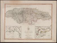
Harbour of Bluefields. and Harbours of Kingston and Port Royal.
Description:
Cross Collection no. 289., From Thomas Kitchin's New universal atlas. 6th ed. London : Robert Laurie and James Whitt, Prime meridians: Ferro and London., Printed no. on verso: 65., and Relief shown by hachures; soundings in fathoms.
Publisher:
Laurie & Whittle,
Subject (Geographic):
Jamaica--Maps--Early works to 1800, Kingston (Jamaica)--Maps--Early works to 1800, and Port Royal (Jamaica)--Maps--Early works to 1800
Subject (Name):
Kitchin, Thomas, 1718-1784. New universal atlas and Laurie & Whittle
Subject (Topic):
Harbors--Jamaica--Kingston--Maps--Early works to 1800 and Harbors--Jamaica--Port Royal--Maps--Early works to 1800