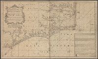
Insets: A Plan of the Harbor of St. Augustine, ca. 1:28,000, 20 x 13 cm.; The Mouth of Nassau River, ca. 1:92,000, 11 x 11 cm.; The Mouth of St. Mary's River ca. 1:112,000, 11 x 10 cm.; The Harbor of Port Royal, ca. 1:400,000, 11 x 14 cm.; Charlestown Har
Insets: Plan of the entrance to Port Manoukao -- Plan of Victoria Bay of Islands New Zealand -- Port Nicholson -- Plan of Dusky Bay -- Plan of Southern Port, Stewarts Island -- -Oyerri or Pelorus River -- Plan of the bar and part of the Hokianga River . and Plan of Port Nicholson and Oyerri by permission of the New Zealand Land Company.
Publisher:
James Wyld, geographer to the Queen, Charing Cross East,
Ordnance Survey of Great Britain and Ireland Royal Geographical Society (Great Britain). Geographical Section
Published / Created:
1915
Call Number:
11hcf 1919E-10
Container / Volume:
BRBL_00010Z
Image Count:
1
Resource Type:
Maps, Atlases & Globes
Alternative Title:
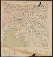
Europe 1:1,000,000, G.S.G.S. ; no. 2758, and GSGS (Series) ; no. 2758.
Description:
Copy 2 imperfect. Mutilated. Browned. Inscription: Charles Seymour. and Includes index to adjoining sheets, index to boundaries, and pronunciation glossary.