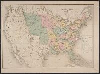
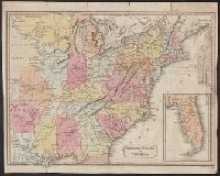
"41" printed in upper right margin., Borders are hand-colored., Imperfect: chipped along edges and torn along fold, with no loss of text., Includes New York State and adjacent areas., and Relief shown by shading.
Publisher:
Pubd. ... by J. Arrowsmith, 33 East St. Red Lion Square,
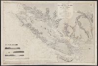
"Juan de Fuca Strait from Capt. Henry Kellett's survey of 1847. Shores of Washington Territory from the United States Coast Survey.", At head of title: North America, west coast., Includes 6 coastal views., and Relief shown by hachures and spot heights. Depths s
Publisher:
The Admiralty,
Subject (Geographic):
Vancouver Island (B.C.)--Maps
Subject (Name):
Arnold, Robert M.--Ownership, Davies & Powell, Mayne, R. C, Powell, E. J, and Richards, G. H. (George Henry)
Subject (Topic):
Coasts--British Columbia--Maps and Coasts--Washington (State)--Maps