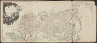
"Printed for Robt. Sayer at No. 53 in Fleet Street, London.", "Published 12th May 1794, by Laurie & Whittle, No. 53, Fleet Street, London.", "To the Right Honourable, George Dunk Earl of Halifax ...", Hand colored., Includes distance chart., and Prime meridians: L
Publisher:
Laurie & Whittle,
Subject (Geographic):
Maryland--Maps, Middle Atlantic States--Maps--Early works to 1800, and Virginia--Maps--Early works to 1800
Subject (Name):
Jefferson, Peter, 1708-1757, Jefferys, Thomas, d. 1771, Robert Laurie and James Whittle, and Sayer, Robert, 1725-1794
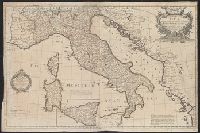
Dedication under coat of arms inscribed Honi Soit Qui Mal y Pense: To His Most Sacred Majesty George by the grace of God King of Great Britain, France and Ireland &c. this map is most humbly dedicated by His Majesty's most loyal & obedient subject and ser
Publisher:
Robt. Sayer at the Golden Buck in Fleet Street,
Subject (Geographic):
Italy--Administrative and political divisions--Maps--Early works to 1800 and Italy--Maps--Early works to 1800
Subject (Name):
Overton, Henry, 1675 or 6-1751 and Sayer, Robert, 1725-1794
Particular map of Baffin and Hudson's Bay and Passage by land to California discover'd by Father Eusebius Francis Kino ...
Description:
"Longit. w. from Ferro.", Hand colored., Includes historical notes, notes on territorial claims, and insets of "A particular map of Baffin and Hudson's Bay" and "The passage by land to California.", and Relief shown pictorially.
Publisher:
Printed for Robert Sayer, no 53 Fleet Street ...,
Subject (Geographic):
North America--Maps--Early works to 1800
Subject (Name):
Gibson, J. (John), active 1750-1792 and Sayer, Robert, 1725-1794
Appears in Thomas Kitchin's General atlas describing the whole universe., Inc, Mounted on linen. Sheet measures 64.4 x 101 cm. Cross Collection no. 176., Relief shown pictorially. Soundings shown in fathoms., and With dedication to John Montagu, Earl of Sandwich.
Publisher:
Printed for Robt. Sayer, map & printseller,
Subject (Geographic):
Saint Lawrence River Valley--Maps--Early works to 1800 and Saint Lawrence River--Maps--Early works to 1800
Subject (Name):
Kitchin, Thomas, d. 1784. General atlas describing the whole universe and Sayer, Robert, 1725-1794
Subject (Topic):
Nautical charts--Saint Lawrence River--Early works to 1800
Appears in Thomas Kitchin's General atlas describing the whole universe., Includes text., and Insets: The Seven Islands -- A continuation of the river from Quebec to Lake Ontario -- St. Nicholas or English Harbor -- The mountains of our Lady or Notre Dame -- Th
Publisher:
Printed for Robt. Sayer, map & printseller,
Subject (Geographic):
Saint Lawrence River Valley--Maps--Early works to 1800 and Saint Lawrence River--Maps--Early works to 1800
Subject (Name):
Kitchin, Thomas, d. 1784. General atlas describing the whole universe and Sayer, Robert, 1725-1794
Subject (Topic):
Nautical charts--Saint Lawrence River--Early works to 1800
Also appeared in Kitchin's General atlas describing the whole universe. London : Printed for Robert Sayer, [1780]., Relief shown pictorially., Sheets m, Sheets mounted together to form 2 sheets., and Title cartouche depicts local produce, a palm tree and a camel.
Publisher:
Printed for Robert Sayer,
Subject (Geographic):
Asia--Maps--Early works to 1800
Subject (Name):
Abbot, Charles,--Baron Colchester,--1757-1829--Bookplate, Anville, Jean Baptiste Bourguignon d', 1697-1782, Cook, James, 1728-1779, Kitchin, Thomas, d. 1784. General atlas describing th, and Sayer, Robert, 1725-1794
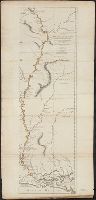
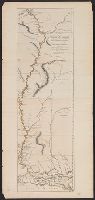
From Jefferys's The American atlas ... London : Printed and sold by R. Sayer and J. Bennett, 1776., Relief shown pictorially; depths by soundings., Sheets pasted together to form 1 sheet. Hand col. Sheets, and Shows forts, Indian villages, etc.
Publisher:
Printed for Robt. Sayer ...,
Subject (Geographic):
Mississippi River--Maps--Early works to 1800
Subject (Name):
Jefferys, Thomas, d. 1771. American atlas and Sayer, Robert, 1725-1794
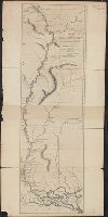
From Jefferys's The American atlas ... London : Printed and sold by R. Sayer and J. Bennett, 1776., Relief shown pictorially; depths by soundings., and Shows forts, Indian villages, etc.
Publisher:
Printed for Robt. Sayer ...,
Subject (Geographic):
Mississippi River--Maps--Early works to 1800
Subject (Name):
Jefferys, Thomas, d. 1771. American atlas and Sayer, Robert, 1725-1794
From Jefferys's The American atlas ... London : Printed, Relief shown pictorially; depths by soundings., and Sheets pasted together to form 1 sheet. Hand col. Sheets measure 62.5 x 55.3 cm. and 60.2 x 55.3 cm. Stamped no. on verso: 25. Cross Collection no. 225.
Publisher:
Printed for Robt. Sayer ...,
Subject (Geographic):
Mississippi River--Maps--Early works to 1800
Subject (Name):
Jefferys, Thomas, d. 1771. American atlas and Sayer, Robert, 1725-1794