Date from entry in catalog of the Royal Geographical Society., Includes table "Methodical division of Italy.", Includes texts within the map explaining various political divisions and their histories., Includes three bar scales, onl, and Relief shown pictorially.
Publisher:
John Bowles ... and Carrington Bowles,
Subject (Geographic):
Italy--Maps--Early works to 1800
Subject (Name):
Bowles, Carington, 1724-1793, Bowles, John, 1701-1779, Kitchin, Thomas, d. 1784, and Palairet, Jean, 1697-1774
Map of New England, New Yorke, New Iersey, Mary-land & Virginia
Description:
"Separate publication ca. 1676" (McCorkle 38)., Includes hand colored illustration of American Indians., Relief shown pictorially., and Verso: Partially stamped "Yale University".
Publisher:
Sould by Robert Morden ... and by William Berry ... ,
Subject (Geographic):
Middle Atlantic States--Maps--Early works to 1800 and New England--Maps--Early works to 1800
Subject (Name):
Berry, William, fl. 1669-1708 and King, Gregory, 1648-1712, engraver
"Longit. west from Ferro I.", "Printed for John Bowles at the Black Horse in Cornhill & Carington Bowles in St. Pauls Church yard, London.", and Differs from other copy in coloration. Only boundaries are colored, emphasis is on showing the internal boundaries o
Publisher:
Printed for John Bowles,
Subject (Geographic):
North America--Maps--Early works to 1800
Subject (Name):
Bowles, Carington, 1724-1793, Bowles, John, 1701-1779, and Palairet, Jean, 1697-1774
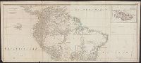
Also appeared in Kitchin's General atlas describing the whole universe. London : Printed for Robert Sayer, [1780]., Includes descriptive notes and text "Division of South America with a summary account of its trade," and large ornamental cartouche., Inset map: Chart of the Falkland's Islands : named by the French Malouine Islands, and discovered by Hawkins in the year 1595. Scale [ca. 1:2,000,000]., Prime meridian: Ferro., Relief shown pictorially; depths by soundings., Sheets measures 54 x 122.7 cm., and Sheets mounted together to form 2 sheets.
Publisher:
Printed for Robert Sayer,
Subject (Geographic):
Falkland Islands--Maps--Early works to 1800 and South America--Maps--Early works to 1800
Subject (Name):
Anville, Jean Baptiste Bourguignon d', 1697-1782, Kitchin, Thomas, d. 1784, and Kitchin, Thomas, d. 1784. General atlas describing the whole universe
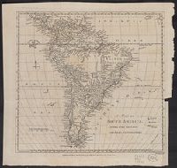
Both sheets backed with paper., Includes text and historical notes., Inset: Chart of Falkland Islands named by the French Malouine Islands and discovered by Hawkins in the year 1593., Outline color., Prime meridian: Ferro., Relief sh, and Watermarks on both sheets.
Publisher:
Sayer and Bennett,
Subject (Geographic):
Falkland Islands--Maps--Early works to 1800 and South America--Maps--Early works to 1800