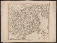
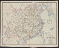
From Cary's new universal atlas ... London : Printed for J. Cary, 1808., Ms. no. on verso: 26. Hand col. Sheet measures 52.1 x 68.2 cm. Cross Collection no. 106., Prime meridian: Greenwich., and Relief shown pictorially.
Publisher:
J. Cary,
Subject (Geographic):
China--Maps
Subject (Name):
Cary, John, ca. 1754-1835. Cary's new universal atlas
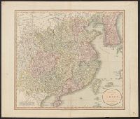
From Cary's new universal atlas ... London : Printed for J. Cary, 1808., Label on verso: 46. Hand col. Sheet measures 54.2 x 63.8 cm., Prime meridian: Greenwich., and Relief shown pictorially.
Publisher:
J. Cary,
Subject (Geographic):
China--Maps
Subject (Name):
Cary, John, ca. 1754-1835. Cary's new universal atlas
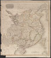
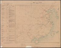
Covers eastern China, southward from Chahar-Jehol (present Inner Mongolia) to Hainan and eastward from Szechwan to East China Sea., Includes inset showing China/Burma border area., Relief shown by hachure, and Shows Chinese territories under Japanese occupation.
Publisher:
Chinese Ministry of Information,
Subject (Geographic):
China--Maps
Subject (Topic):
Sino-Japanese War, 1937-1945--Occupied territories--Maps
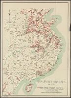
"The London Geographical Institute, M.C.H.", Includes inset maps of Taiwan (Formosa) and Karafuto (Sakhalin), same scale., and Shows Japan, Korea, and the eastern coast of China, railways, air routes, and shipping routes.
"The London Geographical Institute, M.C.H.", Includes inset maps of Taiwan (Formosa) and Karafuto (Sakhalin), same scale., and Shows Japan, Korea, and the eastern coast of China, railways, air routes, and shipping routes.