Search
You Searched For
Search Results
- Published / Created:
- 1796
- Call Number:
- 755cea 1796
- Container / Volume:
- BRBL_00441
- Image Count:
- 3
- Resource Type:
- Maps, Atlases & Globes
- Found in:
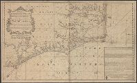
- Beinecke Rare Book and Manuscript Library > To His Excellency General George Washington, President of the United States of North America, This Chart Including the Navigation from the Gulf of Florida to Philadelphia, Is respectfully dedicated ... by ... John Hamilton Moore.
- Published / Created:
- 1760
- Call Number:
- 36hc M66 1756
- Container / Volume:
- BRBL_00134
- Image Count:
- 3
- Resource Type:
- Maps, Atlases & Globes
- Found in:
- Beinecke Rare Book and Manuscript Library > To Prince Ferdinand of Brunswich, this plan of the battle of Thonhausen ... by William Roy, captain of engineers, & assistant quatermaster general of the British forces. Surveyed & drawn by Capt. William Roy. Engraved by Thos: Major.
- Published / Created:
- [1738]
- Call Number:
- 785cea 1738
- Container / Volume:
- BRBL_00514
- Image Count:
- 1
- Resource Type:
- Maps, Atlases & Globes
- Found in:
- Beinecke Rare Book and Manuscript Library > To his grace Thomas Hollis Pelham, Duke of Newcastle... : this chart of his majesties province of North Carolina... / James Wimble... 1738.
- Published / Created:
- 1816
- Call Number:
- 59 1816
- Container / Volume:
- BRBL_00317
- Image Count:
- 6
- Resource Type:
- Maps, Atlases & Globes
- Found in:
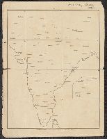
- Beinecke Rare Book and Manuscript Library > To the Honble. the court of directors of the East India Company this improved map of India ... / A. Arrowsmith.
- Creator:
- Wyld, James, 1812-1887
- Published / Created:
- [186-?]
- Call Number:
- 267 1865
- Container / Volume:
- BRBL_00023
- Image Count:
- 1
- Resource Type:
- Maps, Atlases & Globes
- Found in:
- Beinecke Rare Book and Manuscript Library > To the Right Honourable the Secretary of State for the Colonies &c. This chart of New Zealand from original surveys / engraved by Jas. Wyld, Charing Cross East.
- Creator:
- Petermann, A. (August), 1822-1878
- Published / Created:
- 1851
- Call Number:
- 273 1851
- Container / Volume:
- BRBL_00023A
- Image Count:
- 1
- Resource Type:
- Maps, Atlases & Globes
- Found in:
- Beinecke Rare Book and Manuscript Library > To the subscribers to the Borneo Church Mission Institution, this map of Borneo : constructed principally from that of Baron Melvill de Carnbee and the unpublished Admiralty surveys / Augustus Petermann.
- Published / Created:
- [1900?]
- Call Number:
- 321 1900A
- Container / Volume:
- BRBL_00054A
- Image Count:
- 1
- Resource Type:
- Maps, Atlases & Globes
- Found in:
- Beinecke Rare Book and Manuscript Library > Tombleson's Panoramic Map of the Thames and Medway.
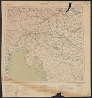
- Creator:
- Ordnance Survey of Great Britain and Ireland
Royal Geographical Society (Great Britain). Geographical Section
- Published / Created:
- 1915
- Call Number:
- 11hcf 1919E-11
- Image Count:
- 1
- Resource Type:
- Maps, Atlases & Globes
- Found in:
- Beinecke Rare Book and Manuscript Library > Triest : North L 33. / compiled at the Royal Geographical Society under the direction of the Geographical Section; drawn and printed by Ordnance Survey.
- Creator:
- Ordnance Survey of Great Britain and Ireland
Royal Geographical Society (Great Britain). Geographical Section
- Published / Created:
- 1915
- Call Number:
- 11hcf 1919E-10
- Container / Volume:
- BRBL_00010Z
- Image Count:
- 1
- Resource Type:
- Maps, Atlases & Globes
- Found in:
- Beinecke Rare Book and Manuscript Library > Triest : North L 33. / compiled at the Royal Geographical Society under the direction of the Geographical Section; drawn and printed by Ordnance Survey.
- Creator:
- Ordnance Survey of Great Britain and Ireland
Royal Geographical Society (Great Britain). Geographical Section
- Published / Created:
- 1915
- Call Number:
- 11hcf 1919E-10
- Image Count:
- 1
- Resource Type:
- Maps, Atlases & Globes
- Found in:
- Beinecke Rare Book and Manuscript Library > Triest : North L 33. / compiled at the Royal Geographical Society under the direction of the Geographical Section; drawn and printed by Ordnance Survey.