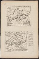
Carte D'une partie de l'Amerique Septentrionale ... prétentions des Anglois au fujét des Limites a' regler avec la France dans cette Partie du Monde.
Description:
Explanation on border., See Phillips 623., and This map is an exact copy from the French Original - T. Jefferys.
Publisher:
T. Jefferys,
Subject (Geographic):
Canada--Maps--Early works to 1800 and East (U.S.)--Maps--Early works to 1800
Date from entry in catalog of the Royal Geographical Society., Includes table "Methodical division of Italy.", Includes texts within the map explaining various political divisions and their histories., Includes three bar scales, onl, and Relief shown pictorially.
Publisher:
John Bowles ... and Carrington Bowles,
Subject (Geographic):
Italy--Maps--Early works to 1800
Subject (Name):
Bowles, Carington, 1724-1793, Bowles, John, 1701-1779, Kitchin, Thomas, d. 1784, and Palairet, Jean, 1697-1774
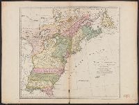
"Longit. west from Ferro I.", "Printed for John Bowles at the Black Horse in Cornhill & Carington Bowles in St. Pauls Church yard, London.", and Differs from other copy in coloration. Only boundaries are colored, emphasis is on showing the internal boundaries o
Publisher:
Printed for John Bowles,
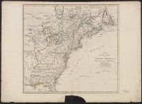
Subject (Geographic):
North America--Maps--Early works to 1800
Subject (Name):
Bowles, Carington, 1724-1793, Bowles, John, 1701-1779, and Palairet, Jean, 1697-1774