Search
You Searched For
Search Results
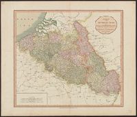
- Creator:
- Cary, John
- Published / Created:
- 1804
- Call Number:
- 335 1804
- Container / Volume:
- BRBL_00086
- Image Count:
- 1
- Resource Type:
- Maps, Atlases & Globes
- Found in:
- Beinecke Rare Book and Manuscript Library > A new map of the Netherlands also of that part of Germany westward of the Rhine as ceded to the French and divided into their several Departments from the latest authorities / by John Cary, Engraver, 1804.
- Creator:
- Cary, John
- Published / Created:
- 1811
- Call Number:
- 335 1811
- Container / Volume:
- BRBL_00086
- Image Count:
- 1
- Resource Type:
- Maps, Atlases & Globes
- Found in:
- Beinecke Rare Book and Manuscript Library > A new map of the Netherlands also of that part of Germany westward of the Rhine as ceded to the French and divided into their several Departments from the latest authorities / by John Cary, Engraver, 1811.
- Creator:
- Philip, George, 1870-1937
- Published / Created:
- [1914.]
- Call Number:
- 11hc 1915B
- Image Count:
- 2
- Resource Type:
- Maps, Atlases & Globes
- Found in:
- Beinecke Rare Book and Manuscript Library > Daily Mail large-scale Military maps No. 3. : The Franco-Belgian Theatre of War / edited by George Philip, F.R.G.S., in conjunction with Military experts.
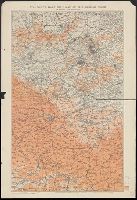
- Creator:
- Edward Stanford Ltd
- Published / Created:
- 1917
- Call Number:
- 11hc 1917P
- Container / Volume:
- BRBL_00010E
- Image Count:
- 1
- Resource Type:
- Maps, Atlases & Globes
- Found in:
- Beinecke Rare Book and Manuscript Library > Stanford's half-inch map of the British front in France & Flanders.