Search
You Searched For
Search Results
- Published / Created:
- [1941]
- Call Number:
- 36hc 1941A
- Container / Volume:
- BRBL_00134
- Image Count:
- 1
- Resource Type:
- Maps, Atlases & Globes
- Found in:
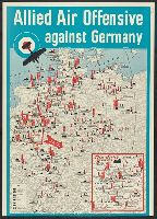
- Beinecke Rare Book and Manuscript Library > Allied air offensive against Germany [cartographic material].
- Creator:
- G.W. Bacon & Co
- Published / Created:
- [ca. 1917]
- Call Number:
- 307hc 1917
- Container / Volume:
- BRBL_00036A
- Image Count:
- 2
- Resource Type:
- Maps, Atlases & Globes
- Found in:
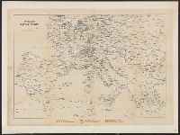
- Beinecke Rare Book and Manuscript Library > Bacon's map of the seat of war in the North Sea, Belgium and eastern France.
- Published / Created:
- [1940]
- Call Number:
- 30gm 1940
- Container / Volume:
- BRBL_00038
- Image Count:
- 1
- Resource Type:
- Maps, Atlases & Globes
- Found in:
- Beinecke Rare Book and Manuscript Library > Central Europe -- Transport Map.
- Creator:
- Geographia Ltd
Thomas Cook Ltd
- Published / Created:
- [1890?]
- Call Number:
- 304ag 1890
- Container / Volume:
- BRBL_00034A
- Image Count:
- 1
- Resource Type:
- Maps, Atlases & Globes
- Found in:
- Beinecke Rare Book and Manuscript Library > Cook's map of central Europe.
- Published / Created:
- [1874?]
- Call Number:
- 30 1874A
- Container / Volume:
- BRBL_00032
- Image Count:
- 1
- Resource Type:
- Maps, Atlases & Globes
- Found in:
- Beinecke Rare Book and Manuscript Library > Cruchley's map of Europe shewing the political divisions and all railways, cities, towns &c.
- Creator:
- George Philip & Son
London Geographical Institute
- Published / Created:
- [1941?]
- Call Number:
- 11hd 1939B
- Image Count:
- 1
- Resource Type:
- Maps, Atlases & Globes
- Found in:
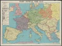
- Beinecke Rare Book and Manuscript Library > Daily Express war map [cartographic material] / the London Geographical Institute KCL.
- Creator:
- George Philip & Son
London Geographical Institute
- Published / Created:
- 1941
- Call Number:
- 11hd 1941
- Image Count:
- 1
- Resource Type:
- Maps, Atlases & Globes
- Found in:
- Beinecke Rare Book and Manuscript Library > Daily Telegraph war map of the Russian Front [cartographic material] / London Geographical Institute.
- Creator:
- Amshewitz, J. H. (John Henry), 1882-1942
Geographia Ltd
- Published / Created:
- 1914
- Call Number:
- 30 1914E
- Container / Volume:
- BRBL_00032A
- Image Count:
- 1
- Resource Type:
- Maps, Atlases & Globes
- Found in:
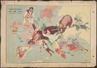
- Beinecke Rare Book and Manuscript Library > European revue : kill that eagle / produced by "Geographia" Ltd. ; [drawn by] J.H.A.
- Creator:
- Hewerdine, Matt
Rose, Fredk. W. (Frederick W.)
- Published / Created:
- [1900]
- Call Number:
- 30 1900
- Container / Volume:
- BRBL_00032
- Image Count:
- 1
- Resource Type:
- Maps, Atlases & Globes
- Found in:
- Beinecke Rare Book and Manuscript Library > John Bull and his friends : a serio-comic map of Europe ... 1900 / by Fred. W. Rose ; Matt. B. Hewerdine from a sketch by Fred. W. Rose.
- Published / Created:
- 1860
- Call Number:
- 30 1860
- Container / Volume:
- BRBL_00032
- Image Count:
- 1
- Resource Type:
- Maps, Atlases & Globes
- Found in:
- Beinecke Rare Book and Manuscript Library > L'Europe en 1860.