Harbour of St. Thomas, the lighthouse bearing N. by E. 1/2 E. 1/3 of a mile, and the signal station N.W. 1/2 N. 3/4 of a mile, St. Thomas Harbour, and View of the Dog Islets taken from the Tow Rock
Description:
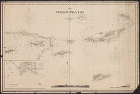
Chart shows Virgin Islands and eastern end of Puerto Rico.
Publisher:
James Imray & Son, 102, Minories,
Subject (Geographic):
Puerto Rico--Maps, Saint Thomas (V.I.)--Maps, and Virgin Islands--Maps
Subject (Name):
James Imray and Son
Subject (Topic):
Views, City (Saint Thomas, V.I) and Views, Topographical (V.I.)