Search
You Searched For
Search Results
- Published / Created:
- [1775?]
- Call Number:
- 76cea 1775A
- Container / Volume:
- BRBL_00446
- Image Count:
- 1
- Resource Type:
- Maps, Atlases & Globes
- Description:
- Insets: The Town of Boston in New
- Subject (Geographic):
- New England--Maps--Early works to 1800
- Found in:
- Beinecke Rare Book and Manuscript Library > A Map of the Coast of New England from Staten Island to the Island of Breton; as it was actualy survey'd by Capt Cyprian Southback.
- Published / Created:
- 1775
- Call Number:
- 771 1775A
- Container / Volume:
- BRBL_00477
- Image Count:
- 2
- Resource Type:
- Maps, Atlases & Globes
- Found in:
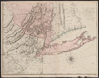
- Beinecke Rare Book and Manuscript Library > Map of the Province of New York with part of Pennsilvania and New England ...
- Published / Created:
- 2 Septr. 1775.
- Call Number:
- 764 B65 1775D
- Container / Volume:
- BRBL_00454
- Image Count:
- 1
- Resource Type:
- Maps, Atlases & Globes
- Description:
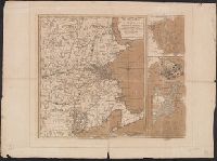
- .] The seat of war in New England -- [2
- Subject (Geographic):
- New England--History--Revolution, 1775
- Found in:
- Beinecke Rare Book and Manuscript Library > The seat of war in New England : with the marches of the several corps sent by the colonies towards Boston, with the attack on Bunkers-Hill / by an American volunteer.
- Creator:
- Jefferys, Thomas, -1771
- Published / Created:
- 15 June 1775.
- Call Number:
- 732 1775
- Container / Volume:
- BRBL_00727
- Image Count:
- 1
- Resource Type:
- Maps, Atlases & Globes
- Subject (Geographic):
- New England--Maps--Early works to 1800
- Found in:
- Beinecke Rare Book and Manuscript Library > A new map of Nova Scotia, and Cape Breton Island : with the adjacent parts of New England and Canada, composed from a great number of actual surveys; and other materials regulated by many new astronomical observations of the longitude as well as latitude