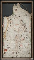
1. Portolan chart of the Mediterranean Sea and the Black Sea Creator: Roselli, Petrus, active 1446-1468, cartographer Published / Created: [approximately 1450-1475] Call Number: Art Storage 49cea 1425 Image Count: 2 Resource Type: cartographic image Description: Portolan chart with seaport names given Subject (Topic): Nautical charts Found in: Beinecke Rare Book and Manuscript Library > Portolan chart of the Mediterranean Sea and the Black Sea